Nature Spots in Iwate Area
Area
-
-
Iwate


-
-
Iwate

Category
-
- Ryusendo Cave
-
![rating-image]() 4.5229 Reviews
4.5229 Reviews - Travel / Tourism
- Iwate Pref. Shimoheiguniwaizumichou Iwaizumi Kannari 1-1
- This massive limestone cave is one of Japan’s three largest, and is designated a National Natural Monument. The cave is over 5,000 meters long overall, and hosts eight underground lakes that are among the clearest in the world. The color of the water, called Dragon Blue, is astonishing and the mystical sight is worth visiting. A 700 meter walking route in the cave and three of the eight lakes are open to the public. One section of the trail is barrier-free, with full wheelchair access. The limestone filtered water has been named one of Japan’s top 100 waters, and is available to drink at the cave entrance.
-
![]()
This spot is far from any station, so you need a car or bus to reach it. The entrance fee costs 1000 yen per person. Business hours are from 8:30 to 17:00, and open everyday. It is one of the three...

-
- Jodogahama Beach
- Travel / Tourism
- Iwate Pref. Miyakoshi Hitachihamachou 32
- This beach is adorned with sharp white rock formations, creating an other-worldly atmosphere. The name Jodogahama refers to the Buddhist “Pure Land.” The beach is filled with bathers in summer. The rock formations visible include flow structures formed by rolling lava, and plate shaped fractures called “joints” formed when magma cools rapidly. The unusual geology led to this area being designated a Sanriku Fukko (reconstruction) National Park & Sanriku Geopark.

-
- Genbikei Gorge
- Travel / Tourism
- Iwate Pref. Ichinosekishi Gembichou Minamitakinoue
- Genbikei is a valley of the Iwai River originating in Mt. Kurikoma and flowing to Ichinoseki City, Iwate Prefecture. Dynamic landscapes such as waterfalls, strangely shaped and magical rocks continue for two kilometers. The specialty of Genbikei is of course the Kakko-dango Dumplings. When ordering and paying, you place your money in a basket attached to a rope stretched to the other side. After sounding a wooden hammer, the basket is pulled up and the dumplings and tea are delivered in return instead. Fun to watch, and delicious to eat.

-
- Yugendo Cave
-
![rating-image]() 3.533 Reviews
3.533 Reviews - Travel / Tourism
- Iwate Pref. Ichinosekishi Higashiyamachounagasaka Higashimotomachi 154-1
- This limestone cave has been forming for about 350 million years. Deep in the cave is a mystical and beautiful emerald green underwater lake. It is also a treasure trove of Japanese fossils including whole trilobites and ancient coral.
-
![]()
ゆっくり見れました。 比較的短い鍾乳洞 中は一般的な照明のみでカラーのライトアップなどはないです。 アップファウンの有るコースと平らなコースに分かれている。 見学料金は大人1100円でした。 お高めだけどノンビリ雰囲気を味わいながら進むと良いです。 入り口と出口は別です。 天井は少し低いのでツバの有る帽子は注意が必要です。

-
- Geibi Gorge
- Travel / Tourism
- Iwate Pref. Ichinosekishi Higashiyamachounagasaka Machi 467
- Geibi Gorge runs along the Satetsu River in Ichinoseki City, and was Iwate prefecture’s first officially designated Place of Scenic Beauty. Its main attraction is the limestone cliff walls rising more than 50 meters. Boating downstream through the river forks between those towering walls is one of Geibi’s true pleasures. There are also many unusual rock formations and caves as well, and the fall colors or spring wisteria offer lovely seasonal beauty. Summer and the fall leaf season also see boat-top tea parties in special tea boats, and in winter you can enjoy a hotpot at a heated kotatsu table as you watch the snowy landscape passing by.

-
- Kappabuchi Stream
- Travel / Tourism
- Iwate Pref. Tonoshi Tsuchibuchichoutsuchibuchi
- Kappabuchi Stream is the birthplace of the legend of kappa in Tono, mischievous water imps. According to the legend, kappa live in a pool in a stream that flows behind Jokenji Temple and like to play tricks on people or startle them. On the banks of the stream is a small outdoor shrine dedicated to the god of the kappa, and it is said that if women with children pray there with their breasts bared, their wish will be granted.

-
- Cape Hirotasaki
-
![rating-image]() 4.03 Reviews
4.03 Reviews - Travel / Tourism
- Iwate Rikuzentakata-shi Hirotacho Atsumari
- This is located in Atsumari, Hirota-cho, Rikuzen-Takata City. Visitors can enjoy the scenery created by the cliffs, the rocky reefs, and the broad expanse of the sea. Aomatsu Island and Tsubaki Island, visible from the shore, are breeding grounds for black-tailed gulls, and Tsubaki Island has been designated a National Monument.
-
![]()
陸前高田の広田湾の先端に位置する岬です.太平洋の大海原を眺めることができる風光明媚な岬です.市内から車で小1時間かかります.

-
- Sakurayama-jinja Shrine
- Travel / Tourism
- Iwate Morioka-shi Uchimaru 1-42
- "This huge rock of about seven meters tall is in the grounds of Sakurayama-jinja Shrine in Morioka Castle Site Park in Morioka City, Iwate Prefecture. It is known to the local residents as ""Guardian Rock"" and is famous for bringing good health and prosperity. The entirety of Sakurayama-jinja Shrine has become a popular spiritual power spot, attracting many worshippers from many regions."

-
- Kitayamazaki
- Travel / Tourism
- Iwate Pref. Shimoheiguntanohatamura Kitayama 129-10
- Gigantic and oddly shaped rocks jut out from cliffs 200 meters high for a stretch of about eight kilometers at Kitayamazaki, one of the world’s best examples of coastal scenic beauty. Since the dynamic series of rocks is reminiscent of a mountain range, this scenic landscape has been called “the Ocean Alps.” Stairs take visitors 736 steps down to the water’s edge, along them to experience the crashing waves at close range.

-
- Goishi Coast
- Travel / Tourism
- Iwate Pref. Ofunatoshi Massakichou Ohama
- Goishi is a coast over 6 kilometers long where you can enjoy a beach of black stone stones like those used for the game of “go” (a strategy board game), a rock with three large holes eroded by the rough waves, and a rock called “Kaminari Iwa” (thunder rock) where the waves breaking sound like the roar of thunder. In 1931, it was designated as a National Place of Scenic Beauty and Natural Monument. At the Goishi Coast Rest House, you can taste Ofunato’s Class B gourmet “Sanma (fish) ramen” and a dish of seafood and rice.

-
- Lake Gando
- Travel / Tourism
- Iwate Prefecture Morioka City Kamogawa Outer Mountain
- An artificial lake located a one-hour bus ride from Morioka Station. The lake was selected for inclusion in list of Top 100 Dam Lakes of Japan in 2005. An area of rich natural beauty located close to the center of Morioka City, the lake is frequented by outdoorsy types looking to enjoy fishing and camping. Particularly famous for its Japanese pond smelt ice fishing in winter, each year during this time the lake bustles with anglers and families. You can purchase a fishing license in the Gandoko Rest House and also rent fishing gear.

-
- Mt. Hachimantai Summit
- Travel / Tourism
- Iwate Hachimantai-shi
- Mt. Hachimantai sprawls almost equally in Hachimantai City, Iwate Prefecture and Akita Prefecture. Due to its rather un-mountain-like shape, in 1962 Iwate Prefecture added soil to the mountain to improve its look. The top of the mountain is a cool 15° C even in the middle of summer, Hachiman Swamp, the largest swamp in Hachimantai, is lush with Asian skunk cabbage, hare's-tail cottongrass, and other alpine plants. The beautiful clear blue waters of the Hachimantai Dragon Eye pond from which it gets its name can only be seen during the season of fresh green leaves in spring.

-
- Matsukawa Gorge
- Travel / Tourism
- Iwate Pref. Hachimantaishi Matsuoyoriki
- A gorge located a 20-minute drive from the Matsuo-Hachimantai Interchange on the Tohoku Expressway. Extending out from the Matsukawa Onsen area, the gorge is one of Hachimantai's top fall foliage viewing destinations. The Matsukawa Genbugan, a local sight, consists of a riverside basalt cliff with pillar-like walls; each year in autumn, the cliff is enwrapped in a sea of beautiful fall foliage. Those walking on the Mori no Ohashi Bridge spanning the gorge can view the sprawling carpet of yellow and gold foliage directly underneath; there's also a parking area, making this a great place to stop and take in the spectacular view.

-
- Kigan Meoto Ishi (Husband and Wife Rock Formation)
- Travel / Tourism
- Iwate Ichinoseki-shi Senmayacho Senmaya Ishido
- This giant natural rock formation is said to represent a married couple. The rocks are about five meters high and ten meters in circumference and are linked by a shimenawa, a sacred Shinto rope. A large represents the man, and another large rock behind him represents the woman. People have been fond of this rock formation since ancient times and consider it to be a divine symbol of marital harmony. Visitors can climb the stairs to see a statue of Kodakara Jizo, the god who grants children to couples, and he is venerated here along with the rocks. Beyond the rocks is a small hill, and beyond that is a small shrine, where the male rock is venerated.
-
- Dewa-jinja Shrine, Haguro Boulders
- Travel / Tourism
- Iwate Tono-shi Ayaoricho Nissato 8-chiwari
- Huge boulders on the grounds of Dewa-jinja Shrine, which honors the Shinto deity Uka-no-Mitama-no-Mikoto. Dewa-jinja Shrine is registered as an Oshu Heritage Site. Since it is located at the summit of Mt. Haguro, to see the boulders you need to pass through Mt. Haguro's torii gate and climb a trail. A legend says the boulders were once even larger but were kicked by a tengu (long nosed goblin), breaking them into smaller pieces. There are a number of the Haguro Boulders, starting with a nine-meter high cracked megalith.

-
- Inari-ana Cave
- Travel / Tourism
- Iwate Tono-shi Miyamoricho
- A limestone cave famous for its pure spring water. The highly regarded spring has been selected as one Iwate's Top 20 Water Sources. There is also an Inari Shrine there and a vermilion torii gate as you approach the cave. There are two areas to collect water, one at the front of the cave and one further back. There is also a tricycle parking area nearby for the convenience of locals collecting water. This pure spring water is used to grow wasabi, a local specialty.

-
- Hittori Marsh
- Travel / Tourism
- Iwate Shimohei-gun Iwaizumicho
- The central marsh of the Kitakami Highland, it is off Prefectural Route 171 (Okawa-Matsukusa Line) accessible from National Route 340. The springtime Asian skunk cabbage, early summer rhododendrons, and autumn leaves are all beautiful. It's an Iwate Prefecture nature preserve, as well as a plant community forest reserve managed by Forestry agency, and has been selected as one of Japan’s top 100 natural landscapes for the 21st century. You can walk along established routes through the nature reserve. In spring the boardwalk is lined with Asian skunk cabbage, and rhododendrons are at their best in mid-July. Cows are visible at pasture in the distance.

-
- Yamada Bay
- Travel / Tourism
- Iwate Shimohei-gun Yamadamachi
- This bay is located in the eastern part of Iwate Prefecture. The Ria coastal inlet can be found in the northern part of the Sanriku Coast, and extends northeast towards the Pacific Ocean. It covers a circumference of approximately 30 kilometers, and the coast, resembling a still round mirror, reflects the brilliant green pine trees on the white rock surface. The large and small islands floating quietly in the center of the bay are also covered in brilliant green trees, and with the bay encompassing them, it seems like a giant-sized miniature garden. Many oysters and scallops are cultivated in the bay with its gentle waves, and it has been named the Lake Towada of the sea. At present, recovery operations are steadily making progress to repair damage caused by the 2011 earthquake.
-
- Kurosaki Point
- Travel / Tourism
- Iwate Shimohei-gun Fudaimura
- This earth village is located at 40° North latitude in Fudai Village, Iwate Prefecture. Standing at the Kurosaki Observation Point or the Anmoura Observation Point, visitors can look down at the Pacific Ocean from the steep cliffs and see the curvature of the earth. It has also been designated a “geo site” of Sanriku Geo Park. Fudai considers Kurosaki Observation Point to be its symbol, and other impressive sights include East Point, which exactly marks 40°0’ 0”” North, and the waterfall at Anmoura, the steepest drop in Iwate Prefecture. The name of Anmoura Observation Point, which stands on the edge of a 100-meter cliff, is said to come from an Ainu word that refers to demons and ghosts.

-
- Lake Tase
- Travel / Tourism
- Iwate Hanamaki-shi
- Lake Tase is located about a 20-minute drive from the Towa Interchange on the Kamaishi Expressway. It is an artificial lake, created by damming the Sarugaishi River, and it has been selected as one of the Top 100 Dam Lakes of Japan. Carp, crucian carp, and, in the winter, Japanese smelt and other freshwater fish are easily caught here. The lake is surrounded by a forested park, and visitors can enjoy the fresh greenery or autumn leaves, depending on the season. The Lake Water Festival, held at the end of July, features traditional performing arts, as well as canoeing, yachting, and other water sports, and at night, thousands of fireworks light up the sky.


Iwate Areas
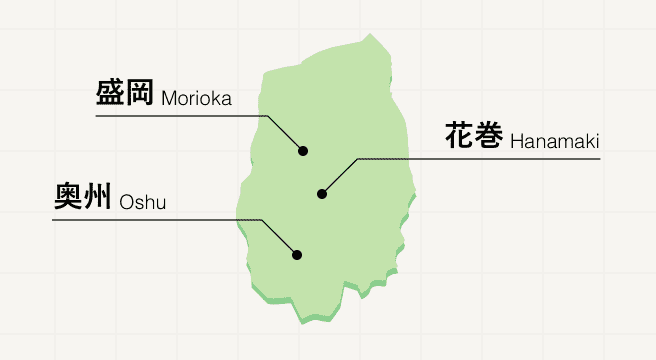
A northern Tohoku prefecture promising peace and quiet, Iwate is sparsely populated, replacing people with snow-capped mountains, history-rich sites, and fields of crops that are to thank for the region’s delicious local cuisine. Meander along the three-city Golden Route, where you’ll visit the grand Buddhist temples of Hiraizumi and the Tono folk villages before tasting the three famed noodle dishes of Morioka.
Iwate Photo Album
Best of Iwate
Search by Region
-
- Hokkaido / Tohoku
- Hokkaido
- Aomori
- Iwate
- Miyagi
- Akita
- Yamagata
- Fukushima
-
- Kanto
- Ibaraki
- Tochigi
- Gunma
- Saitama
- Chiba
- Tokyo
- Kanagawa
-
- Koshinetsu / Hokuriku
- Niigata
- Toyama
- Ishikawa
- Fukui
- Yamanashi
- Nagano
-
- Tokai
- Gifu
- Shizuoka
- Aichi
- Mie
-
- Kinki
- Shiga
- Kyoto
- Osaka
- Hyogo
- Nara
- Wakayama
-
- Chugoku
- Tottori
- Shimane
- Okayama
- Hiroshima
- Yamaguchi
-
- Shikoku
- Tokushima
- Kagawa
- Ehime
- Kochi
-
- Kyushu / Okinawa
- Fukuoka
- Saga
- Nagasaki
- Kumamoto
- Oita
- Miyazaki
- Kagoshima
- Okinawa


