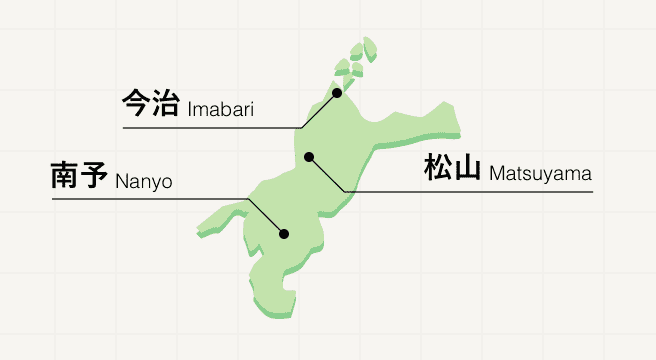
Nature Spots in Ozu / Uwa / Sadamisaki Area
Area
-
-
Ehime


-
-
Ehime
-
-
Ozu / Uwa / Sadamisaki
-
Ozu / Uwa / Sadamisaki

Category
-
- Shikoku Karst
- Travel / Tourism
- Ehime Prefecture/Kochi Prefecture
- Shikoku Karst is a scenic spot noted as being one of the three largest karsts (geological feature) in Japan. The karst stretches for about 25 kilometers east to west and sits at a height of 1,000 to 1,500 meters above sea level. The Shikoku Karst is also the source of the Shimanto River, said to be the last clear stream in Japan on account of there not being any dams on the river. The sight of the Tosa Red cows grazing on the land is both tranquil and beautiful.

-
- Cape Sada
- Travel / Tourism
- Ehime Pref. Nishiuwagunikatachou Shouno
- Located on the westernmost tip of Shikoku on Japan's narrowest peninsula. Here at the edge of the Setonaikai National Park, you'll find the Cape Sada Lighthouse, which was designated as a Tangible Cultural Property of Japan in 2017. The peninsula extends 50 kilometers and is also called the 13-Ri Cape (Ri being an old Japanese measurement equal to approximately 4 kilometers). It is only 0.8 kilometers wide at its narrowest point. The area is overflowing with can't-miss tourist sights including the Cape Sada Melody Line driving course, from which you can have a panoramic view over the Seto Inland Sea, or view a 1,000-year-old giant camphor tree. On sunny days, you can see clearly across the Houyo Straight all the way to Kyushu from the Cape Sada Lighthouse.

-
- Cape Komo
- Travel / Tourism
- Ehime Pref. Minamiuwagunainanchou Koumo
- A cape on the Funakoshi Peninsula jutting out into the Bungo Channel on the southernmost tip of Ehime Prefecture. Consisting of a stretch of cliff more than 100-meter high, the surrounding area is lush with subtropical plants. One of the cape's charms is its diverse scenery. On clear days, visitors can see all the way to Kyushu. Around November each year, falcons visit the cape and gold chrysanthemums which grow thickly in the area come into bloom. As night approaches, the setting sun dyes everything orange. There are also historical sites such as a battery and bunkers built during WWII. Situated far from the city center, the cape is quiet and romantic and also makes a great destination to go on a date.

-
- Hiburi Island
- Travel / Tourism
- Ehime Uwajima-shi Hiburishima
- This island is located in the Uwa Sea to the west of Uwajima City. In olden times, it was known as the base for Fujiwara no Sumitomo, who led pirates in the Inland Sea. The uniquely winding shapes of the inlets, the sea caves, and the rock formations make this a scenic area worth seeing. In addition to rock fishing and line fishing, the island offers a swimming beach that is open in the summer.

-
- Sadamisaki Peninsula
- Travel / Tourism
- Ehime Nishiuwa-gun Ikatacho
- This peninsula located in Ikata Town, Nishiuwa County is the westernmost peninsula in Shikoku. Known for being the slenderest peninsula of its length in Japan, it stretches east to west between the Seto Inland Sea and the Uwa Sea for some 40 kilometers. The peninsula is dotted with places of scenic beauty and historical heritage sites such as the Sadamisaki Lighthouse that stands on its tip. Other attractions include beaches, campgrounds, and resorts.

-
- Hoketsu Pass
- Travel / Tourism
- Ehime Seiyo-shi Uwacho Uwajima-shi
- This pass lies between Kaida, Uwa-cho,Seiyo City and Hoketsu, Yoshida-cho, Uwajima City. At present, National Route 56 passes under it via a tunnel, but the former road, which goes over the pass, still exists. The summit of the pass is at 436 meters and is well known as a scenic spot with a view of the ria coast of the Uwa Sea from the observation point that has been set up there.

-
- Genji-ga-Daba
- Travel / Tourism
- Ehime Seiyo-shi Nomuracho Onogahara
- This karst plateau straddles Onogahara, Nomura-cho, Seiyo City, Ehime Prefecture and Yusuhara Town, Takaoka County, Kochi Prefecture. It is part of the Shikoku karst, one of the three major karsts in Japan, and it is located at an altitude of 1,400 meters. Legend has it that the name Genjigadaba dates from the Genpei War 1180-1185, when the remnants of the Heike, the losing side, saw the limestone extending over the plateau, mistook them for the horses of their opponents, the Genji, and fled. The gentle terrain is used extensively for dairy farming.
-
- Onogahara Highland
- Travel / Tourism
- Ehime Seiyo-shi Nomuracho Onogahara
- "This is a highland in Nomura-cho, Seiyo City. It is located on the Shikoku karst, one of the three largest karsts in Japan, at a height of more than 1000 meters. It is a dairy farming region, and there are attractions such as ""The Pony Pasture,"" where visitors can encounter animals, in addition to a lush natural environment with an old-growth beech forest and highland plants."

-
- Kashima Island
- Travel / Tourism
- Ehime Minamiuwa-gun Ainancho Kashima
- This uninhabited island in Ainan Town, Minamiuwa County. It has a lush natural environment designated as Uwa Marine Park, and in former time, it was part of the Uwajima fief and used as the Date clan's hunting grounds. It has a beach that the Ministry of the Environment has selected as one of the Top 88 Swimming Beaches in Japan, as well as a campground. Visitors can enjoy snorkeling and operate marine observation boats to view coral and tropical fish.
-
- Nametoko Ravine
- Travel / Tourism
- Uwajima-shi Ehime Prefecture - Matsuno cho
- The 12 kilometer long Nametoko Ravine lies in the upper course of the Meguro River branch of the Shimanto River. This ravine is abundant with scenic views including the Senjojiki rock and the Yukiwa Falls, selected as one of the top 100 national waterfalls. Also known for its autumn foliage, the ravine covered in bright red and yellow flora is a marvelous sight to see.

-
- Aoshima Island
- Travel / Tourism
- Ehime Ozu-shi
-
- Mt.Gozaisho
- Travel / Tourism
- Ehime
-
- Lake Asagiri
- Travel / Tourism
- Ehime Seiyo-shi
-
- Suzaki Kaigan
- Travel / Tourism
- Ehime Seiyo-shi Mikamecho Shuki
-
- Sekiji Pond
- Travel / Tourism
- Ehime Seiyo-shi Uwacho Higashitada
-
- Yukiwanotaki
- Travel / Tourism
- Ehime Uwajima-shi Nogawa
-
- Mt.Sanbongui
- Travel / Tourism
- Ehime
-
- Mt.Takatsuki
- Travel / Tourism
- Ehime
-
- Mt.Izushi
- Travel / Tourism
- Ehime
-
- Mt.Kannan
- Travel / Tourism
- Ehime

Ehime Areas
Stretched across the northwest corner of Shikoku island, Ehime is a nature-rich prefecture boasting beautiful coastlines and a rural center where mountains play host to 26 of the Buddhist temples that make up the Shikoku Pilgrimage. Matsuyama is home to an original post-feudal castle as well as Dogo Onsen, one of the country’s oldest natural hot springs. The northern city of Imabari marks the entrance to the Shimano Kaido, a road that crosses six spectacular bridges and several islands, forming a route between Shikoku and mainland Honshu.
Ehime Photo Album
Best of Ehime
Search by Region
-
- Hokkaido / Tohoku
- Hokkaido
- Aomori
- Iwate
- Miyagi
- Akita
- Yamagata
- Fukushima
-
- Kanto
- Ibaraki
- Tochigi
- Gunma
- Saitama
- Chiba
- Tokyo
- Kanagawa
-
- Koshinetsu / Hokuriku
- Niigata
- Toyama
- Ishikawa
- Fukui
- Yamanashi
- Nagano
-
- Tokai
- Gifu
- Shizuoka
- Aichi
- Mie
-
- Kinki
- Shiga
- Kyoto
- Osaka
- Hyogo
- Nara
- Wakayama
-
- Chugoku
- Tottori
- Shimane
- Okayama
- Hiroshima
- Yamaguchi
-
- Shikoku
- Tokushima
- Kagawa
- Ehime
- Kochi
-
- Kyushu / Okinawa
- Fukuoka
- Saga
- Nagasaki
- Kumamoto
- Oita
- Miyazaki
- Kagoshima
- Okinawa


