Nature Spots in Mt. Ishizuchi / Shikoku Karst Area
Area
-
-
Ehime


-
-
Ehime
-
-
Mt. Ishizuchi / Shikoku Karst
-
Mt. Ishizuchi / Shikoku Karst

Category
-
- Shikoku Karst Tengu Kogen
- Travel / Tourism
- Kochi Takaoka-gun Tsunocho Yoshiunootsu
- A highland area with magnificent nature that brushes the sky. It has lots of walkways, making it ideal for hiking. If you are lucky, visiting early in the morning will let you witness a sea of clouds spreading below. At night you can enjoy the near endless starry sky. The grasslands will be sure to please year-round.

-
- Kuma Kogen
-
![rating-image]() 5.01 Reviews
5.01 Reviews - Travel / Tourism
- Ehime Kamiukena-gun Kumakogencho
- This town is located in central Ehime prefecture. It's surrounded by outstanding natural scenery, with the Shikoku Karst field, one of Japan's three largest, western Japan's tallest peak of Mt. Ishizuchi, and Omogokei gorge, the source of the Niyodo River. It offers a taste of nature year round, with its average height of 800 meters resulting in a cool climate that's perfect for outdoor activities like mountain climbing, skiing, and delicacy hunting.
-
![]()
ご夫婦二人で老後の楽しみに…と花桃を植え始めたのが始まりだそうです。 満開の様はまさに桃源郷の景観です。 手作りの展望台から観る満開の花々は本当に絶景ですよ!! 園主のおばあさんはにこやかな笑顔で迎えてくださいました。 おじいさんにはご挨拶できず… ご近所の方?たちも誘導やお接待の手伝いをされていて、自家製のホットゆずジュースを振る舞ってくださいました。 ミツバチがたくさん飛んでいましたので...
-
- Mezurudaira
- Travel / Tourism
- Ehime Pref. Kamiukenagunkumakougenchou Nishidani ・ Kohara-cho, Takaoka-gun, Kochi Prefecture
- One of Japan's three best karsts alongside Akiyoshidai in Yamaguchi Prefecture and Hiraodai in Fukuoka Prefecture. It's located along the border to Kochi Prefecture nearly three kilometers from Jiyoshi Pass. As you leave the pass and reach the peak on this popular driving course your field of view suddenly widens and you'll find facilities such as a parking area and a camp ground. Alpine plants bloom across the flat plain during the summer and from spring to fall you'll see cattle grazing. The soft serve ice cream sold at ''Mezuruso'', marked by its peaked roof, has a reputation for being rich an addictive.

-
- Suiha Kogen Highland
- Travel / Tourism
- Ehime Pref. Shikokuchuoushi Kinshachouhiranoyama
- This highland in Shikokuchuo City centers around Mt. Suihamine and sits almost 890 meters above sea level. Enjoy a fantastic 360-degree panoramic view of various islands in the Seto Inland Sea and the Shikoku mountain range. Come see the amazing scenery of golden rapeseed flowers covering the land in spring or cosmos flowers from summer to early fall. This is also a popular cherry blossom viewing location as from mid-April to May the Yoshino cherry, hill cherry, and double-flowered cherry are all in full bloom. There is also a children's area with a playground, toilets, and a parking lot. Many tourists visit during the spring when the flowers bloom like a carpet.

-
- Omogo Gorge
- Travel / Tourism
- Ehime Pref. Kamiukenagunkumakougenchou Wakayama
- "This gorge spreads out near the foot of Mt. Ishizuchi upstream on the Niyodo River in Kochi Prefecture where the clear blue ""Niyodo blue"" has gained attention. The river that flows there is very clear, and you can see all the way to the riverbed. There are two main promenades, the main route connecting sights such as Goshiki-gawara Riverbed, Momiji-gawara Riverbed and Torigataki Falls, and the Teppo route along the quiet Teppo River. The surrounding forest has also been selected as one of the Top 100 Forested Water by the Forestry Agency, and is also known as a nationally designated scenic spot. How it looks changes in various ways depending on the season, and it is also popular as a spot for seeing colorful leaves in the autumn."

-
- Namegawa Gorge
- Travel / Tourism
- Ehime Pref. Touonshi Myouga
- This hinterlands valley is around 8 kilometers from the famous cherry-blossom viewing area, Sakura-Sanri, along National Route 11. Come experience the mysteries of nature in this valley and see the Namera, a river bed made from one large spacious rock that stretches almost a kilometer in length, as well as potholes formed by smaller stones caught in the whirlpools cutting into the larger boulders. A popular spot in the spring when the new verdant green leaves emerge and during the summer as a cool place to escape the heat. With amazing autumn colors in the fall and icicles stretching longer than two meters in the winter, there's something to enjoy here year-round. This valley with its mysterious rockface formed over countless years has certainly earned its reputation as a secluded natural power spot (spiritual place with energy vortex).

-
- Shirai Falls
- Travel / Tourism
- Ehime Pref. Touonshi Kawanouchi
- This famous waterfall has been repeatedly featured in short literary works and verses by great haiku poet s including Masaoka Shiki and Natsume Soseki. Located in Saragamine Mountain Range Prefectural Natural Park, this majestic waterfall cascades a distance of 96-meters. Parking facilities, an esplanade to the waterfall, and a viewing platform make it possible for anyone to visit. The Shirai Falls Festival is held every year on November 3rd, and with the nearby trees dyed in autumn splendor, mochi dumplings are tossed to the crowd while local produce is available for purchase. During the winter the entire falls freezes over, giving it the wondrous appearance of an ice sculpture.

-
- Furuiwaya
- Travel / Tourism
- Ehime Pref. Kamiukenagunkumakougenchou Naose
- These giant conglomerate stone spires, which towers over its surroundings and has some 20-million years of stratum, has been the nationally designated Place of Scenic Beauty. The sight of 20-some strange spires ranging in height from 60 to 100 meters tall will take your breath away. The naked rock face has had countless holes carved into it by water erosion over the years, leading to it being named Furuiwaya. Known for beautiful autumn colors, tourists flock to the area when the trees start changing in early November to see the contrast between the vivid fall colors and the unyielding rock face.

-
- Mt. Ishizuchi
- Travel / Tourism
- Saijo City, Ehime Pref.
- At 1,982 meters tall this sacred mountain, also called the roof of Shikoku, is the tallest mountain in west Japan. It stands over Saijo City and Kumakogen Town and from the highest point, Tengudake peak, you can of course see the Seto Inland Sea but also the mountains in the Chugoku and Kyushu regions. It is counted alongside Mt. Fuji, Mt. Tateyama, Mt. Hakusan, Mt. Shakagatake, Mt. Omine, and Mt. Daisen as one of Japan's Seven Holy Mountains. The area around Mt. Ishizuchi has been designated a quasi-national park and displays a different mysterious form every season. The four separate chained areas for climbing the mountain are a rarity nationwide. As there are detours it is safe even for beginners.

-
- Godan Kogen Highlands
- Travel / Tourism
- Ehime Pref. Kamiukenagunkumakougenchou Nishidani
- Also known as ''Heaven's Road'', this highland runs alongside Prefectural Route 383. You can walk here from Mezurudaira, located in the center of the Shikoku Karst. The peak, sometimes called Godan Castle, sits almost 1,456 meters above sea level. On clear days you can see Mt. Ishizuchi, Tosa Bay, and the Shikoku mountain range. The highland is well deserving its title as the foremost viewing spot of the Shikoku karst with the ''Karrenfeld'' exposed limestone rocks and a basin-like ''doline'' sinkhole. The road has been chosen as one of the top 100 roads of Japan with its beautiful scenery that makes you feel like you're amongst the beautiful blue sky and pure white clouds.

-
- Mt. Kamegamori
- Travel / Tourism
- Saijo City, Ehime Prefecture, Kamogawa-gun, Kochi Prefecture
- This mountain, a two-hour drive from the Iyo-Komatsu Interchange on the Matsuyama Expressway, has been selected as one of the 300 Famous Japanese Mountains. The peak sits at 1,897 meters above sea level with a plain spread across the peak. The contrast and beauty between the fir and Japanese hemlock and the sun-bleached stumps earns this area's name of Shikoku's Panorama Platform. The local road Kamegamori line, commonly called the UFO Line (Yuho Line), is a beautiful 27 kilometers driving route with Mt Ishizuchi, west Japan's tallest holy mountain, in the background. On clear days you can see as far as the Pacific Ocean and the road has been used for TV commercials. It's a popular mountain for beginner climbers and the summit can be reached in one hour from the trailhead.

-
- Lake Kurose
- Travel / Tourism
- Ehime Pref. Saijoushi Kurose
- Located an approximately ten-minute drive from Kamogawa Bridge or approximately 30 minutes by bus from Iyo-Saijo Station on the JR Yosan Line, this multipurpose dam lake for Kurose Dam dammed up the Kamo River and was completed in 1973. There are two parks, No. 1 Park and No. 2 Park, and many people visit for picnics, hiking and bass fishing. Cherry trees are planted along the vicinity of the lake, and in the spring you can enjoy the scenery with fresh greenery and cherry blossoms reflected in the lake's surface. It has been designated as a special protected area as a destination for the endangered Baikal teal.
-
- Tomisato Gorge
- Travel / Tourism
- Ehime Shikokuchuo Tomisatocho Tsuneyama
- This gorge is in Tomisato-cho, Shikokuchuo City. In this gorge, which extends for six kilometer in the upper reaches of the Dozan River and forms a scenic area, red pines and spike mosses grow on the 60-meter rock walls of Modorigadake. In the summer, visitors can enjoy stream fishing, and in the fall they can look for autumn leaves.

-
- Mt. Iwaguro
- Travel / Tourism
- Ehime Kamiukena-gun Kumakogencho Wakayama Kochi Agawa-gun
- This is a 1,746 meter mountain that straddles the boundary between Wakayama, Kuma Kogen-cho, Kamiukena County in Ehime Prefecture and Nishinokawa, Saijo City, Ehime Prefecture and Inomachi, Agawa County, in Kochi Prefecture. It is the endpoint of the Ishizuchi Skyline Drive, and visitors can climb to the summit of Mt. Ishizuchi from the earthen hut that marks the trail head. It is a famous spot for viewing Akebono azaleas in the spring.

-
- Mimidodake Rock
- Travel / Tourism
- Ehime Kamiukena-gun Kumakogencho Shide
- "This is a rock formation along the Omogokawa River in Kumakogen Town in Kamiukena County. Pine trees flourish on top of this limestone rock wall, 37 meters tall and 137 meters wide. Due to its shape, it is also called ""Battleship Rock.” It has been designated as a Prefectural Famous Place. Many people enjoy camping and other outdoor activities along the riverbanks in the summer."

-
- Jiyoshi Pass
- Travel / Tourism
- Ehime Kamiukena-gun Kumakogencho Nishidani Kochi Takaoka-gun Yusuharacho
- Located on the Shikoku karst, one of Japan's three major karsts, this pass lies on the boundary between Kumakogen Town, Ehime Prefecture and Yusuhara Town, Takaoka County, Kochi Prefecture. Pot-shaped sinkholes and white limestone rocks lie scattered around this meadow landscape, giving visitors a massive view of natural beauty.

-
- Yakama no Oketsugun
- Travel / Tourism
- Ehime Kamiukena-gun Kumakogencho Yanaigawa
- This is a cluster of ouketsu (giant's kettles) in Yanaigawa, Kumakogen town, Kamiukena district. There are roughly 30 of these holes worn in the stone by flowing water and stones in the river, making a rare site that is a designated National Natural Monument. The Yakama (eight pots) name comes from the eight particularly large holes. There are roughly 1. 2 kilometers of maintained trail along national route 440.
-
- Tomisato Dam
-
![rating-image]() 3.56 Reviews
3.56 Reviews - Travel / Tourism
- Ehime Shikokuchuo Tomisatocho Tsuneyama 353-6
-
![]()
渓谷沿いの絶景が楽しめるので、ドライブにもってこいのスポットです。秋には紅葉も楽しむことができます。近くには大きな橋がいくつもあるので、橋と山をバックにきれいな写真をとることができます。
-
- Mt.Nakatsu (Mt.Myojin)
- Travel / Tourism
- Ehime
-
- Otani Ike (Saijo)
- Travel / Tourism
- Ehime Saijo-shi Komatsucho Shinyashiki Otani


Ehime Areas
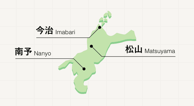
Stretched across the northwest corner of Shikoku island, Ehime is a nature-rich prefecture boasting beautiful coastlines and a rural center where mountains play host to 26 of the Buddhist temples that make up the Shikoku Pilgrimage. Matsuyama is home to an original post-feudal castle as well as Dogo Onsen, one of the country’s oldest natural hot springs. The northern city of Imabari marks the entrance to the Shimano Kaido, a road that crosses six spectacular bridges and several islands, forming a route between Shikoku and mainland Honshu.
Ehime Photo Album
Best of Ehime
Search by Region
-
- Hokkaido / Tohoku
- Hokkaido
- Aomori
- Iwate
- Miyagi
- Akita
- Yamagata
- Fukushima
-
- Kanto
- Ibaraki
- Tochigi
- Gunma
- Saitama
- Chiba
- Tokyo
- Kanagawa
-
- Koshinetsu / Hokuriku
- Niigata
- Toyama
- Ishikawa
- Fukui
- Yamanashi
- Nagano
-
- Tokai
- Gifu
- Shizuoka
- Aichi
- Mie
-
- Kinki
- Shiga
- Kyoto
- Osaka
- Hyogo
- Nara
- Wakayama
-
- Chugoku
- Tottori
- Shimane
- Okayama
- Hiroshima
- Yamaguchi
-
- Shikoku
- Tokushima
- Kagawa
- Ehime
- Kochi
-
- Kyushu / Okinawa
- Fukuoka
- Saga
- Nagasaki
- Kumamoto
- Oita
- Miyazaki
- Kagoshima
- Okinawa


