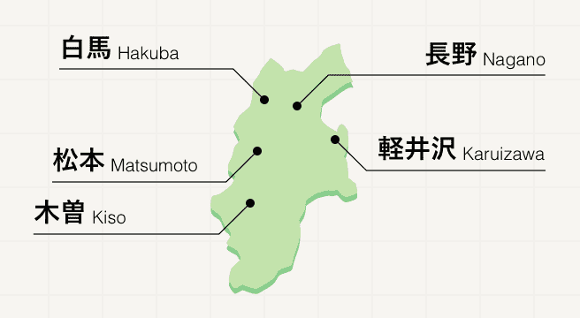
Nature Spots in Eastern Shinshu Area
Area
-
-
Nagano


-
-
Nagano

Category
-
- Shiraito Falls
- Travel / Tourism
- Karuizawa-cho, Kitasaku-gun, Nagano Prefecture
- The result of underground water welling out of bare rock, Shiraito Falls has a thin stream of water almost like a strand of silk with beautiful lines of water and white spray falling down. The refreshing sight is one of Karuizawa’s representative sightseeing spots. In the winter, icicles are artificially created using water gushing forth from the waterfall, producing a fantastical atmosphere.

-
- Kumoba Pond
- Travel / Tourism
- Nagano Pref. Kitasakugunkaruizawamachi Karuizawa
- This pond located in close proximity to Roppon-tsuji serves as the water source for gozen-sui. The quiet, beautiful pond is also called Swan Lake since swans used to migrate here in the past. A promenade has been built around the circumference of the pond upon which visitors can enjoy a slow stroll. Visits during the autumn season with its changing leaves are particularly recommended. The sight of the trees steeped in red and yellow reflected in the water is well worth seeing.

-
- Inagura Rice Terraces
-
![rating-image]() 4.012 Reviews
4.012 Reviews - Travel / Tourism
- Nagano Pref. Uedashi Tonoshiro
- "An area of terraced rice fields sprawling at the foot of mountains in the Tonoshiro area in Ueda City. The fields were cultivated between the Genroku and Meiji periods (1688-1912). After being selected as one of the 100 most beautiful rice terrace areas in Japan, conservation activities were initiated to preserve the fields. School extracurricular activity programs are conducted in the area as well as programs such as the ""Terrace Rice Owner System"" and ""Sake Rice Owner System"" which allow regular people to experience the entire rice production process from planting to harvesting and receive a bag of rice they made, or a bottle of sake created from the rice they harvested."
-
![]()
青空の下、美しい棚田に感動しました。 ドライブ途中に立ち寄りましたが、稲刈り前の時期も良かったです。 見学には協力金100円必要。

-
- Yachiho Lake
-
![rating-image]() 3.59 Reviews
3.59 Reviews - Travel / Tourism
- Nagano Prefecture Minamisaku-gun Sakuho-cho
- A lake located in Sakuho Town, Minamisaku County, Nagano Prefecture with a sweeping view of Mt. Asama and the Arafune Highland. Located in the center of the Yachiho Highland, the lake is notable for the beautiful white birch forest which surrounds it. Also a renowned fishing destination for catching trout and char, many people come here to enjoy fishing in the great outdoors.
-
![]()
沢山の釣り人がいました。眺めがよく、気持ち良い場所です。白樺も沢山ある見ごたえのある場所です。天気も良く、景色が映える感じです。
-
- Utsukushigahara Highlands
- Travel / Tourism
- Nagano Pref. Matsumotoshi Iriyamabe
- Utsukushi-ga-Hara Highlands which is a part of the largest quasi-national park in Nagano Prefecture is the largest plateau in Japan sitting at an elevation of close to 2,000 meters above sea level. The superb 360 degree panorama rewards visitors with views overlooking the Northern and Southern Alps, and Mt. Fuji. The mountain top Utsukushi-ga-Hara Highlands has trails and hiking paths so you can fully enjoy the magnificent nature and fresh air.

-
- Mugikusa Pass
- Travel / Tourism
- Nagano Prefecture Minamisaku-gun Sakuho-cho
- A pass situated along the Merchen Highway in a national forest in Yakori, Sakuho Town, Minamisaku County. Located between Mt. Maru and Mt. Chausu. Shirakoma Pond, Japan's largest natural lake above 2,100 meters above sea level, is located nearby. Note that the pass is closed to traffic in winter.

-
- Hirasawa Pass
- Travel / Tourism
- Nagano Pref. Minamisakugunminamimakimura Nobeyama
- This pass is located in Minami-maki Village in Minami-saku County, Nagano Prefecture. The dividing ridge between the Pacific Ocean and the Sea of Japan, the pass forms the boundary where rainwater can flow in either direction. The starting point for climbing Mt. Iimori, besides a parking lot and bathrooms, there is also an observatory where you can get magnificent views of Mt. Yatsugatake, the Southern Alps and Mt. Fuji.

-
- Lake Matsubara
- Travel / Tourism
- Nagano Prefecture Minamisaku-gun, Koumi cho
- A lake located in Koumi Town, Minamisaku County, Nagano Prefecture also known as Ina Lake. A walking path encircles the lake and visitors can rent a boat or stay at a nearby bed and breakfast. A well-known fishing spot, in summer many people come to catch Japanese crucian carp and in winter, Japanese pond smelt. Also a renowned fall foliage destination, during the peak period in autumn, a great many visitors come here to enjoy the scenery.

-
- Lake Megami
- Travel / Tourism
- Nagano Pref. Kitasakuguntateshinamachi Ashitahatsukano
- "A lake located in Ashidahakkano, Tateshina Town, Kitasaku County. Situated 1,500 meters above sea level, the lake is 1.8 kilometers in circumference. ""Megami"" means ""goddess"" in Japanese, and the lake gets its name from the picturesque sight of Mt. Tateshina, also known as ""Goddess Mountain,"" reflected off of its waters. During warmer months, visitors can enjoy canoeing and boating on the lake, while in the winter area activities include ice driving on its frozen waters, snowshoeing, and cross-country skiing."

-
- Uchiyama Gorge
-
![rating-image]() 3.01 Reviews
3.01 Reviews - Travel / Tourism
- Nagano Saku-shi Uchiyama
- Located about 10 minutes by bus from Nakagome Station or about 20 minutes by car from the Saku Minami IC, this valley near Route 254 is a place where visitors can enjoy the magnificent nature with many strange and mysterious rocks such as Hime-Iwa, Napoleon-Iwa, Byobu-Iwa, and Candle-Iwa. The area is also a great place to enjoy the changing scenery of the four seasons, with peach blossoms in early May and cosmos in mid-September.
-
![]()
奇岩の景勝地として知られていますが、駐車場や中心地がありません。 まあ、山の紅葉と岩肌なのでどこからでも見えるのですが、観光を楽しむとか散策をたのしむとかができるとよいかな。

-
- Mt. Arafune
- Travel / Tourism
- Gunma Prefecture Takara-gun Shimanita-cho, Nagano Prefecture Saku City
- This is a famous mountain located in the Myogi-Arafune-Saku Kogen Quasi-National Park in the southwestern part of Gumma Prefecture. The mountain has an altitude of 1,423 meters is one of 200 hundred famous mountains in Japan. The mountain became a table-shaped plateau after many years of erosion. It is said that it was named because the flat top and the steep cliffs looks like a ship breaking through rough waves. The cliffs are an overwhelming 200 meters high. Many climbers visit throughout the year and as there are several climbing courses, you can choose the route best suited to your skills.

-
- Karasawa Falls
- Travel / Tourism
- Nagano Pref. Uedashi Sugadairakougen 1223
- A five-minute walk from the nearest bus stations and a 25-minute drive from the Ueda-Sugadaira Interchange. This waterfall is located at the entranceway to the Sugadaira Highland, which sprawls at the feet of Mt. Azumaya and Mt. Neko. 15 meters tall and 10 meters wide, the waterfall is most notable for the white, curtain-like wall of water it forms when the river flow is strong the day after a rain. Another of the waterfall's charms is the seasonal variability of its beauty, with fresh and lush verdure enwrapping it in early summer, while the trees surrounding the waterfall turn crimson and gold in the fall. A Jomon period rock shelter is located right next to the waterfall.

-
- Arafune Lake
- Travel / Tourism
- Nagano Pref. Sakushi Uchiyama
- This lake is located inside of the Uchiyama Farm Camping Ground along the Myogi-Arafune forest road in Uchiyama, Saku City. A promenade has been built on the side of the lake and visitors can view the Asamafuro, a near-threatened species of geranium, that grow in mass on the lakeshore from July to August. The lake also has a fishing pond (anglers must bring their own fishing equipment).

-
- Lake Inako / Lake Choko
- Travel / Tourism
- Nagano Pref. Minamisakugunkoumimachi Toyosato 4253-1
- These lakes are located along Prefectural Route 480 in Toyosato, Koumi Town, Minamisaku County. Of all the nearby lakes often collectively referred to as Matsubara Lake, Lake Inako and Lake Choko are especially popular as Japanese crucian carp fishing spots. From April to October, anglers can enjoy fishing on a more than 1,000-meter-high plateau. In the winter, it is possible to go ice fishing for Japanese pond smelt. Visitors can also commune with nature by strolling the lakeside promenade.

-
- Matsubarako Highland
- Travel / Tourism
- Nagano Pref. Minamisakugunkoumimachi Toyosato 5918-2
- This plateau is located in Toyosato, Koumi Town, Minamisaku County near Lake Inako, Lake Choko, and Lake Otsuki, which are collectively referred to as Lake Matsubara. It features a variety of facilities including hot springs and camp grounds as well as sporting facilities such as a skating center and tennis courts. Visitors can also enjoy activities such as boating and strolling along the lakeshore. Anglers can fish for Japanese crucian carp on the lake and even go ice fishing for Japanese pond smelt in the winter.
-
- Yashigamine
- Travel / Tourism
- Nagano Kitasaku-gun Tateshinamachi
- "The area is a treasure trove of alpine flora, and in early summer, cherry violets, buttercups, day lilies, and azaleas bloom in profusion at the foot of the mountain. In winter, the northwestern slope becomes ""Shirakaba-ko Royal Hill Ski Resort."
-
- Cosmos Kaido
- Travel / Tourism
- Nagano Saku-shi Uchiyama
- A 20-minute drive from the Saku-minami Interchange. A highway close to Uchiyama Valley on National Route 254. A popular tourist destination, here visitors can enjoy a comfortable drive along a nine kilometer stretch of road along which cosmos, the official flower of Saku City, have been planted. The flowers bloom from early to late September. The flowers were first planted by a local senior citizens' club in 1972; today, the scenic road is maintained by local residents. The Saku Kogen Cosmos Festival is held in mid-September and during this time a tea cafe opens up; visitors can also try dying a handkerchief.

-
- Mt. Ushibuse
- Travel / Tourism
- Nagano Ueda-shi Takeshi
- Located on the Utsukushi-ga-hara Plateau in Ueda City, the mountain is about 1,990 meters high, but it is a small hill-like mountain with well-maintained wooden paths, making it easy to enjoy climbing. It is also known for its famous morning glow, and many people climb the mountain in the morning to see the mountains turn into a brilliant color.

-
- Ryugaeshi Falls (Suzuga Falls)
- Travel / Tourism
- Nagano Kitasaku-gun Karuizawamachi
- Located in Nagakura, Karuizawa-cho, Kitasaku-gun, this beautiful white waterfall flows through a green forest and is part of the Shinanoji Nature Trail, a hiking course through the forests of Karuizawa.

-
- Senga Falls
- Travel / Tourism
- Nagano Kitasaku-gun Karuizawamachi
- "Located in Nagakura Senkedaki, Karuizawa-cho, Kitasaku-gun, this waterfall boasts the largest waterfall in Karuizawa, with a drop of approximately 20 m. A walking trail ""Senkadaki Seseragi no Michi"" has been developed around the waterfall, providing a hiking course to enjoy the fresh green leaves in spring and the autumn leaves in fall, as well as the nature along the mountain stream."


Nagano Areas
Nagano prefecture is an exciting mix of mountains, hot spring monkeys, and preserved Edo history. At the heart of the Japanese Alps, Nagano is one of the country’s most popular destinations, whether in winter for its snow sports and the much-loved Jigokudani Monkey Park or in the warmer months for discovering the undulating hills on foot. For fantastic Edo architecture, head to the Kiso Valley for a 60-kilometer stretch of quaint wooden buildings that marked the Nakasendo route 200 years ago.
Nagano Photo Album
Best of Nagano
Search by Region
-
- Hokkaido / Tohoku
- Hokkaido
- Aomori
- Iwate
- Miyagi
- Akita
- Yamagata
- Fukushima
-
- Kanto
- Ibaraki
- Tochigi
- Gunma
- Saitama
- Chiba
- Tokyo
- Kanagawa
-
- Koshinetsu / Hokuriku
- Niigata
- Toyama
- Ishikawa
- Fukui
- Yamanashi
- Nagano
-
- Tokai
- Gifu
- Shizuoka
- Aichi
- Mie
-
- Kinki
- Shiga
- Kyoto
- Osaka
- Hyogo
- Nara
- Wakayama
-
- Chugoku
- Tottori
- Shimane
- Okayama
- Hiroshima
- Yamaguchi
-
- Shikoku
- Tokushima
- Kagawa
- Ehime
- Kochi
-
- Kyushu / Okinawa
- Fukuoka
- Saga
- Nagasaki
- Kumamoto
- Oita
- Miyazaki
- Kagoshima
- Okinawa


