Nature Spots in Okinawa Area
Area
-
-
Okinawa


-
-
Okinawa

Category
-
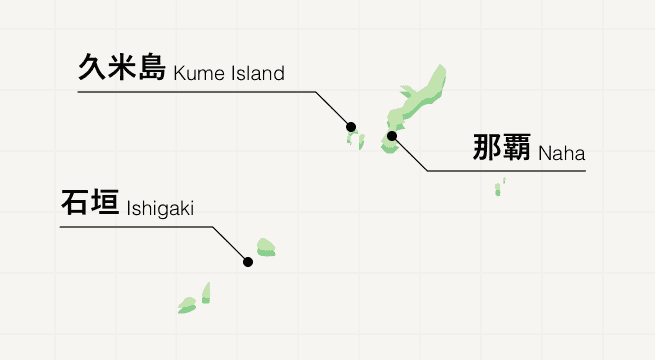
- Kume Island
- Travel / Tourism
- Okinawa Pref. Shimajirigunkumejimachou
- Situated approximately 100 kilometers west of Naha, the island is located in the most westerly position of the Okinawan archipelago. Since the Ryukyu dynastic period, it was also called “Kumi island” due to its beauty. Such as the reef “Hateno beach”, the pure white sands made from coral and the beauty of the cobalt blue sea—It is said to be the most beautiful in the Orient. On the other hand, this is also an ideal diving spot where you can encounter humpback whales, whale sharks, dolphins, etc. There are a number of strong Okinawan liquors (Awamori) distilled from rice or millet from Kume Island and these are also very popular among strong Okinawan liquors. In 1983 in the Showa period, almost all of the island was designated as a prefectural natural park.

-
- Ida no Hama (Beach)
- Travel / Tourism
- Okinawa Pref. Yaeyamaguntaketomichou Iriomote
- Ida Beach is located in Funauki on the southwestern part of Iriomote Island. With crystal clear seas and a wide shallow sandy beach, it is also a popular place to bring children for sea bathing. As a result of there being no roads leading to Funauki, the only way to reach is to take a ferry (approximately 10 minutes) from the port of Shirahama. Ida Beach is about 10 minutes on foot from the port of Shirahama.

-
- Mariyudu Waterfall
- Travel / Tourism
- Okinawa Pref. Yaeyamaguntaketomichou Uebaru
- Mariyudu Waterfall is located upstream of the Urauchi River on Iriomote Island in Okinawa Prefecture, which has been selected as one of the 100 best Japanese waterfalls. Mari means “round” and Yudu means “Stagnation”, and as this name suggests, one of its characteristic is that the basin under the waterfall is round. You will arrive at the waterfall by walking about 40 minutes through the jungle from the sightseeing boat’s upstream docking station, but be careful as it can be slippery.

-
- Kaiji Beach
- Travel / Tourism
- Okinawa Pref. Yaeyamaguntaketomichou Taketomi
- Kaiji Beach is a beautiful beach on Taketomi Island which is famous as you can find star sand on it. It is also known as the “star sand beach”. It is also good to walk and search for star sand and gaze at the cobalt blue sea from the shade of the Hasuno clover trees. However, swimming is prohibited due to strong currents.

-
- Cape Takanazaki
- Travel / Tourism
- Okinawa Pref. Yaeyamaguntaketomichou Hateruma
- Cape Takanazaki is located to the south-east of Hateruma Island. It is a cape pounded by wild waves with a coast of sheer cliffs extending for roughly one kilometer. It is a picturesque place where you can enjoy the force of the waves which rise with a splash and the clear cobalt blue sea right in front of your eyes. There are three monuments lined up, a monument of the southernmost point in Japan, a monument of Hateruma and a monument of peaceful prayers. As there is also a Star Observatory Tower nearby, you can also enjoy the starlit sky at night.

-
- Cape Irizaki & Monument of the Westernmost Point of Japan
- Travel / Tourism
- Okinawa Prefecture Yaeyama-gun Yonaguni Machihisa BuRyo
- Yonaguni Island is located at the westernmost end of Japan. The cape at the westernmost extremity of the island is Irizaki, and on a sunny day, you can command a view of the silhouette of Taiwan in the distance. Built on the leading edge of the cape with its sheer cliffs of more than 50 meters in height is a lighthouse, an observation platform and a “Monument of the Westernmost Point of Japan”. The setting sun is a magnificent sight as it shines orange and dissolves in the cobalt blue sea. Also, the Yonaguni-Cho Tourism Association has published evidence that this is the westernmost point of Japan.

-
- Tategamiiwa Rocks
- Travel / Tourism
- Okinawa Prefecture Yaeyama-gun Yonaguni-cho
- These are oddly-shaped rocks which tower up and are located on the south-eastern coast of Yonaguni Island. As legend has it, in olden times, a young person climbed these rocks in order to try to get sea bird eggs, but could not get down from the rocks. He fell asleep when praying to God and when he awoke he had safely returned from the rocks. There are two observation platforms which command a view of Tategamiiwa Rocks: one is an old observation platform which is located 600 meters west of the “Sanninu” parking lot. The other is a new observation platform which is located approximately 500 meters west of the old observation platform.

-
- Cape Agarizaki
- Travel / Tourism
- Okinawa Prefecture Yaeyama-gun Yonaguni Higashizaki Machi
- Cape Agarizaki is a cape at the easternmost tip of Yonaguni Island. It is a cape covered with idyllic meadows, and there is a lighthouse and a viewing platform at the tip of the cape—you can get an unbroken view of the cobalt blue sea which spreads out under the sheer cliffs. Yonaguni horses and cattle are graze in the meadow, and you can gaze at the tranquil rural landscape.

-
- Nishibama Beach
- Travel / Tourism
- Okinawa Pref. Shimajirigunzamamison Aka
- "Approximately a five-minute drive from Aka Port, this is the main beach of Aka Island, an island located to the west of the main island of Okinawa. Despite the characters of its name meaning ""north beach,"" they are pronounced as ""nishibama,"" which means ""west beach."" The contrast between the transparent beautiful ocean and the pure white sands that stretch for one kilometer is very appealing. Although lifeguards are only on duty from May to around September, you can enjoy swimming there year-round at your own risk. In addition, it is also extremely popular as a snorkeling spot because of the colorful corals and tropical fish that can be seen. You can also enjoy other marine activities such as diving and sea kayaking."

-
- Kayauchi Banta
- Travel / Tourism
- Okinawa Pref. Kunigamigunkunigamison Ginama
- "A picturesque cliff located in Kunigami Village on the northern tip of Okinawa Island. ""Banta"" means ""cliff"" in the Okinawan dialect. The 80-meter-high, precipitous cliff faces the East China Sea and offers a sweeping view of the ocean in Okinawa Kaigan Quasi-National Park. From an observatory, visitors can look down the steep cliff walls and at the surrounding beauty of the ocean and natural scenery. Visitors can also walk along a walking path or relax in an arbor on the cliff. On clear days, visitors can see the gentle ocean and Ginama Fish Harbor directly below and beautiful steep mountains stretching into the distance."

-
- Kurima Island
- Travel / Tourism
- Okinawa Pref. Miyakojimashi
- This small island is southwest of Miyako Island and has a circumference of just nine kilometers. Surrounded by the emerald green sea, this serene locale is nearly entirely occupied by sugarcane and leaf tobacco fields. The 1,690-meter Kurima-ohashi Bridge links the island to Miyako Island, from which you can gaze down at the beautiful coral reef while crossing.

-
- Komaka Island
- Travel / Tourism
- Okinawa Pref. Nanjoushi Chinen Azama Offing
- This uninhabited island floats off the coast of Chinen Village in southern Okinawa Prefecture. It’s accessible via a 15-minute boat ride from the Chinen Marine Leisure Center. The fine, white sand and crystal clear emerald-green sea will enrapture you, and you can enjoy sea bathing and marine sports to your heart’s content. The island has nothing but a bathroom, so be sure to bring what you need with you.

-
- Ikema Island
- Travel / Tourism
- Okinawa Pref. Miyakojimashi Hirara Ikema
- This island floats about 1.5 kilometers northwest of Miyako Island, with which it is connected by the 1,425-meter-long Ikema-ohashi Bridge. The crystal clear sea viewable from this perfectly straight bridge is a sight to behold. There are plenty of beaches with gorgeous white sand, making it a great destination for ocean lovers. On Ikuzu Beach lies what is referred to as the “Heart Rock,” which features a heart-shaped hole.

-
- Odohama Beach
- Travel / Tourism
- Okinawa Pref. Itomanshi Odo
- During the Bakumatsu period, when the country was closed to outsiders, John Manjiro came back from America and landed at this beach, thus leading it to sometimes be referred to as “John Man beach.” The water is crystal clear, and coral reefs can be seen during low tide. Snorkeling and diving are recommended as well. The beach is also known as a spot that sea turtles often visit in summer to lay their eggs.

-
- Shimajiri Mangrove Forests
- Travel / Tourism
- Okinawa Prefecture
- The Shimajiri Mangrove Forests are mangrove forests that have grown along a roughly one kilometer long inlet in the northern part of Miyako-jima (Miyako Island). This is the largest group of mangrove forests in the Miyako Islands; visitors can view a variety of different mangrove species while strolling along wooden walkways. Many wild bird species live in the mangrove forests, making this a popular place for bird-watching. At low tide, large numbers of crabs can be seen.

-
- Ie Village Mt. Gusuku
- Travel / Tourism
- Okinawa Pref. Kunigamigunieson Higashieue
- Ie Village Mt. Gusuku is a 172 meter-high hill on Ie-jima (Ie Island). The hill has a unique shape; when viewed from the ocean, it was said to resemble an Eboshi (a cap used by men in Heian period), and since ancient times it was used as a landmark for navigation at sea. It is known colloquially as “Gusuku” or “Gusuku-yama.” From the summit, there are superb views of the entire island, and of the East China Sea.

-
- Okuma Beach
- Travel / Tourism
- Okinawa Pref. Kunigamigunkunigamison Okuma
- Managed by Okuma Private Beach & Resort, Okuma Beach is beautiful beach with a one kilometer-long stretch of fine-grained white sand. The emerald-green sea is ideal for paddling, swimming and water sports. The glass-walled beach café offers terrace seats where visitors can enjoy light meals, alcoholic beverages etc. in a spacious, relaxed atmosphere.

-
- Hiyajo Banta Cliff
- Travel / Tourism
- Okinawa Pref. Shimajirigunkumejimachou Hiyajou
- "This precipitous cliff approximately 200 meters above the sea is situated along Prefectural Route 242 between the communities of Hiyajo and Aka. From this scenic destination, on clear days visitors can see all the way to Hatenohama and even the Kerama Islands. ""Banta"" means ""cliff"" or ""precipice"" in the Okinawa language. There's an observatory and shop on a hill near the road, as well, making this a viable rest point when going on a drive around the island."

-
- Minna Island
- Travel / Tourism
- Okinawa Pref. Kunigamigunmotobuchou Sesoko Mizushima
- An island which looks like the shape of a croissant when seen from the air. Around a 15-minute ferry-ride from the main island of Okinawa. Encircled by white sands and cobalt-blue ocean, popular activities on this isolated island include snorkeling and other marine sports. There are also diving areas and walking destinations.

-
- Gesashi Bay's Mangrove Forest
- Travel / Tourism
- Okinawa Pref. Kunigamigunhigashison Gesashi
- Gesashi Bay’s Mangrove Forest is the largest area in Okinawa Main Island to be able to view mangroves. You can experience canoeing as well as viewing three types of mangroves: black mangroves, Kandelia obovata and Rhizophora mucronata. In 1972, it is designated as a national Natural Monument.


Okinawa Areas
Let go of your image of a busy, ordered Japan and replace it with crystal-clear waters, white sand beaches, and relaxing folk music: You’ve arrived in Okinawa. A world away from the high intensity of Tokyo, Okinawans appear to live a laid-back beach life on this paradisiacal tropical island that lies in the middle of the East China Sea almost 1,000 kilometers south of mainland Japan’s most southern tip. Home to a spattering of islands, prepare yourself to discover underwater caves, star-shaped sand, and an island culture sometimes unrecognizable from mainland Japan.
Okinawa Photo Album
Best of Okinawa
Search by Region
-
- Hokkaido / Tohoku
- Hokkaido
- Aomori
- Iwate
- Miyagi
- Akita
- Yamagata
- Fukushima
-
- Kanto
- Ibaraki
- Tochigi
- Gunma
- Saitama
- Chiba
- Tokyo
- Kanagawa
-
- Koshinetsu / Hokuriku
- Niigata
- Toyama
- Ishikawa
- Fukui
- Yamanashi
- Nagano
-
- Tokai
- Gifu
- Shizuoka
- Aichi
- Mie
-
- Kinki
- Shiga
- Kyoto
- Osaka
- Hyogo
- Nara
- Wakayama
-
- Chugoku
- Tottori
- Shimane
- Okayama
- Hiroshima
- Yamaguchi
-
- Shikoku
- Tokushima
- Kagawa
- Ehime
- Kochi
-
- Kyushu / Okinawa
- Fukuoka
- Saga
- Nagasaki
- Kumamoto
- Oita
- Miyazaki
- Kagoshima
- Okinawa


