Nature Spots in Kushimoto / Koza / Susami Area
Area
-
-
Wakayama


-
-
Wakayama

Category
-
- Cape Shionomisaki
-
![rating-image]() 4.0135 Reviews
4.0135 Reviews - Travel / Tourism
- Wakayama Pref. Higashimurogunkushimotochou Shionomisaki
- At latitude 33° 25′ 59″ North and longitude 135° 45′ 45″ East, this cape is on the southern most tip of Honshu island. The vast expanse of the sea making an arc at the horizon is a site to see, especially at sunset when the whole sky is painted in coral colors. From the nearby observatory, Mt. Nachi can be seen.
-
![]()
Must visit when in the area. Dramatic view all around this area. The sea is so beautiful, but can be very cruel

-
- Hashikuiiwa Rocks
- Travel / Tourism
- Wakayama Prefecture Higashimuro-gun Kushimoto-cho Hashikui
- The Hashikuiiwa Rocks are about 40 rocks of various sizes in a row towering over the seashore from Kushimoto heading towards Oshima. The name comes from the fact that the row of rocks stretching for about 850 meters looks as though bridge piles have been left on the shore. At low tide visitors can walk to Bentenjima Islet which is nearly in the middle of the row. In addition to this sightseeing spot being selected as one of Japan’s 100 best places to watch the sunrise, as it is popular to watch the sun rise over the Hashikuiiwa Rocks, it has also been designated as a National Place of Scenic Beauty and a Natural Monument.

-
- Ichimai-iwa Monolith
- Travel / Tourism
- Wakayama Higashimuro-gun Kozagawa Cho Aise
- "This huge crag towers along the Kozagawa River and has been designated a National Natural Monument. The cliff can be seen from Roadside Station Ichimaiiwa on National Route 371 on the other side of the Kozagawa River. Roughly 100 meters tall and 500 meters wide, it is one of the largest single blocks of bedrock found in Japan. In the Edo period ""Kii zoku fudoki"" chronicle, it is described as ""A truly sacred place and perhaps the most amazing sight in the world."" Visitors can also enjoy the changing seasonal beauty of the cherry trees, Tricyrtis macranthopsis, and other plants which grow in the area. A campground sprawls along the river and in the summer the area bustles with campers."

-
- Umikongo
- Travel / Tourism
- Wakayama Pref. Higashimurogunkushimotochou Kashino
- Named after Mt. Kumgang, a Place of Scenic Beauty on the Korean Peninsula, this picturesque scenery features a series of precipitous cliffs. The sight of the huge rocks rising perpendicularly almost like a pyramid with raging waves smashing against the cliffs makes for a powerful sight. The Japan-U.S. Friendship Memorial Museum on the premises has displays of photos and a diorama which tell about the time when two US merchant ships, the Lady Washington and the Grace, landed at Oshima.

-
- Mushikui-iwa Rock
- Travel / Tourism
- Wakayama Higashimuro-gun Kozagawa Cho Ikenoyama
- "A 10-minute drive from JR Koza Station. This rock formation is located right next to Roadside Station Mushikui-iwa and has been designated a National Natural Monument. The name of the formation could literally be translated as ""Moth-eaten Rock,"" and just as its name suggest, the huge mass of liparite has been eroded by wind and rain resulting in holes which make it look like moth-eaten cloth. It is believed the curious erosion pattern is a result of minute crystals forming when water evaporates on the rock; this in turn results in the surface of the rock slowly being removed. A part of the natural Kozagawa Dike, an area selected for inclusion in a list of Geology 100 selections of Japan, legend has it that visiting the formation aids in the healing of ear ailments."

-
- Eight Beautiful Views of Susami Koibitomisaki (Lover's Waves)
- Travel / Tourism
- Wakayama Nishimuro-gun Susami Cho Mirozu 2-1
- "An eight-minute drive from JR Susami Station. This peninsula is one of the Eight Beautiful Views of Susami, and here visitors can watch as the ocean crashes into and is split into two by Okanokuroshima, them comes together again beyond it. One of the most picturesque destinations on the Kareki Sea, the waves are also known as the ""Husband and Wife Waves."" The area has also been selected for inclusion in a list of the 100 best sunrises and sunsets in Wakayama. On the west side of Okinokuroshima, there is a cave which continues under the sea, and scuba diving can be enjoyed in the area from March to the end of April, and from late June to the end of October. According to legend, the treasure of the Kumano Navy is hidden in the cave."

-
- Eight Beautiful Views of Susami Esuzaki Cape
- Travel / Tourism
- Wakayama Nishimuro-gun Susami Cho Esumi
- A five-minute drive from Roadside Statin Susami off of the Susami-Minami Interchange on the Kisei Expressway. One of the Eight Beautiful Views of Susami and also a designated Geosite, this island, connected to the mainland via a strip of land, juts out into the Pacific Ocean. Two kilometers in circumference, it is densely covered with woodland elaeocarpus, yew plum pine, ubame oak, and other subtropical trees and plants and has been designated a National Natural Monument. The entire island is also a sacred precinct of Kasuga Shrine. The Children's Song Park, which is dotted with statues depicting characters from nursery rhymes connected to Wakayama, is situated in front of the island.

-
- Eight Beautiful Views of Susami Kotono-taki Falls
- Travel / Tourism
- Wakayama Nishimuro-gun Susami Cho Susami
- A 10-minute drive from JR Susami Station and one kilometer from the parking area of Kotonotakiso via the Hirose Valley Trail, which starts at the rear of the parking area. One of the Eight Beautiful Views of Susami, this waterfall is the furthest upstream of the more than 10 waterfalls in the Hirose Valley, which lies along a tributary of the Susami River. The valley has been designated a Nature Conservation Area by Wakayama Prefecture and the plants and animals found here are protected. The waterfall area is a great place to bathe in beautifying negative ions and enjoy an invigorating nature walk. A site where a Warring States period military commander once hid from enemies is also located further upstream from the falls.

-
- Eight Beautiful Views of Susami Shizukuno-taki Falls
- Travel / Tourism
- Wakayama Nishimuro-gun Susami Cho Okauchi
- A 20-minute drive from JR Susami Station on Prefectural Route 38. One of the Eight Beautiful Views of Susami, this beautiful two-tier waterfall is 30 meters tall and lies along the main course of the Susami River. An abundant amount of water flows down the falls; the upper tier is broad and the water here veritably glides down the rock wall, while the water of the lower tier drops heartily into the plunge basin. Many people come here seeking to escape the heat in summer; many people enjoying fishing for sweetfish, Amago trout, and other river fish can also be seen in the area. The area's fresh verdure in early summer, and autumn foliage in fall are particularly stunning. A walking path leads down to the falls, making it easy for visitors to take in its natural beauty up close.

-
- Oka-no-Kuroshima Island
- Travel / Tourism
- Wakayama Nishimuro-gun Susami Cho Mirozu
- "This small island can be seen right in front of Lover's Cape, known as one of the Eight Beautiful Views of Susami. Here visitors can view a spectacular natural phenomenon in which ocean waves, divided in two by the island, come crashing together again on the other side as they flow in towards Lover's Cape. Called the ""Worshipping Waves"" and the ""Husband and Wife Waves,"" this spectacular sight is one of the Kareki Sea's most beautiful and most well-known."

-
- Oki-no-Kuroshima Island
- Travel / Tourism
- Wakayama Nishimuro-gun Susami Cho Mirozu
- This small island is situated southwest of Lover's Cape, one of the Eight Beautiful Views of Susami. The island has a cave which continues under the sea, and from March to the end of April, and from late June to the end of October, scuba diving can be enjoyed here. Records state the island once served as a base for the Kumano Navy and legend has it that the navy's treasure is hidden somewhere on or under the island.

-
- BotanIwa
- Travel / Tourism
- Wakayama Higashimuro-gun Kozagawa Cho Tsukinose
- "This intriguing rock formation is located southeast of the Kozagawa Dike, a 22-kilometer-long stretch of the 56-kilometer-long Kozagawa River formed via ancient volcanic activity. The rock surface, carved out by the actions of the wind over eons, is covered in holes, and small mounds of various sizes can be seen rising up within these same holes. The name of the formation literally means ""Tree Peony Rock"" and is derived from the resemblance of these holes and mounds to tree peonies. According to local legend, a great snake lived on the opposite shore, and in order to pass by the rock formation without being attacked by the snake, one would have to cough and clear one's throat before walking by."

-
- Tenchugan
- Travel / Tourism
- Wakayama Higashimuro-gun Kozagawa Cho Kurozu
- This rock formation is located just on the west side of the Ichimai-iwa Monolith, one of the most famous sights along the Kozagawa Dike, a 22-kilometer-long stretch of the 56-kilometer-long Kozagawa River which was formed via ancient volcanic activity. Sticking out like a peninsula among the mountains, seen from below, the stunning rock formation exudes a majestic air. Amidst greenery-covered mountains, this chunk of rock, although bearing trees in some places, is largely uncovered stone, and its spectacular form, thrusting towards the heavens, impresses upon viewers the power of nature.

-
- IimoriIwa
- Travel / Tourism
- Wakayama Higashimuro-gun Kozagawacho
- "This rock formation is located east of the Ichimai-iwa Monolith, one of the most famous sights along the Kozagawa Dike, a 22-kilometer-long stretch of the 56-kilometer-long Kozagawa River which was formed via ancient volcanic activity. The formation can just be seen amidst the mountains from the Tachiai Bridge along National Route 371. Its name literally means ""Rice Mound Rock"" and is derived from its resemblance to a heaping mound of cooked rice. Be sure to check it out along with the numerous other sightseeing destinations along the Kozagawa River."
-
- Kuroshima Island
- Travel / Tourism
- Wakayama Pref. Higashimurogunkushimotochou Koza
- "Located approximately one kilometer off the coastal mouth of the Kozagawa River, this island covered with Machilus thunbergii trees of the laurel family. It is said that this island was once a hub for the Kumano Navy that fought in the Genpei battles. In recent years, the Obon season draws beach swimmers and canoeing and kayaking visitors. It is also known as the site for shooting the variety show Ikinari! Ogon Densetsu, where the television character Yoiko lived on this uninhabited island. This island is one of the cultural properties which compose ""Living with whales"", designated as Japan Heritage by Agency of Cultural Affairs."

-
- Takinohai
- Travel / Tourism
- Wakayama Higashimuro-gun Kozagawa Cho Kogawa
- This place is located approximately a 30-minute drive from the JR Koza Station. It is situated in a stream that is a tributary of Koza River, and the ground, pocked with holes of varying sizes extends for around 200 meters. The holes were formed by flowing water and small stones, and there is a waterfall in the middle. Although it is not a very high waterfall, the water glides along the sharp edges of the rocks, giving it power and momentum. A few patterns of the Takinohaitarou folktale remain, and every year in July, Bouzuhaze goby and Yoshinobori goby fish can be seen swimming up the rocks. The basin of the waterfall is a popular spot for fishermen who are looking to catch sweetfish.

-
- Kashino Cape
- Travel / Tourism
- Wakayama Higashimuro-gun Kushimotocho Kashino
-
- Mt.Kasane
- Travel / Tourism
- Wakayama Higashimuro-gun Kushimotocho
-
- Kin no Taki
- Travel / Tourism
- Wakayama Nishimuro-gun Susamicho
-
- Hiro Sedani Valley
- Travel / Tourism
- Wakayama Nishimuro-gun Susamicho


Wakayama Areas
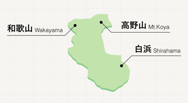
Wakayama prefecture unites pilgrims, food lovers, and culture buffs in a tranquil corner of Japan at the base of the Kii Peninsula. The setting for many a Kumano Kodo pilgrimage trail, Wakayama invites those in search of spirituality from one side of the prefecture to the other, from the 100-plus Buddhist temples of the sacred Mount Koya in the west to the inspiring temples of the Kumano Sanzan set among breathtaking nature in the east. Once the grueling hike is complete, make a beeline for Wakayama city to savor some of the country’s most delicious ramen noodles.
Wakayama Photo Album
Best of Wakayama
Search by Region
-
- Hokkaido / Tohoku
- Hokkaido
- Aomori
- Iwate
- Miyagi
- Akita
- Yamagata
- Fukushima
-
- Kanto
- Ibaraki
- Tochigi
- Gunma
- Saitama
- Chiba
- Tokyo
- Kanagawa
-
- Koshinetsu / Hokuriku
- Niigata
- Toyama
- Ishikawa
- Fukui
- Yamanashi
- Nagano
-
- Tokai
- Gifu
- Shizuoka
- Aichi
- Mie
-
- Kinki
- Shiga
- Kyoto
- Osaka
- Hyogo
- Nara
- Wakayama
-
- Chugoku
- Tottori
- Shimane
- Okayama
- Hiroshima
- Yamaguchi
-
- Shikoku
- Tokushima
- Kagawa
- Ehime
- Kochi
-
- Kyushu / Okinawa
- Fukuoka
- Saga
- Nagasaki
- Kumamoto
- Oita
- Miyazaki
- Kagoshima
- Okinawa


