Skyline, etc. Spots in Fukui Area
Area
-
-
Fukui


-
-
Fukui

Category
-
- Mikatagoko Rainbow Line
- Travel / Tourism
- Fukui Pref. Mikatakaminakagunwakasachou Kiyama 18-2-2
- The Rainbow Line is a toll road with a total length of 11.24 kilometers that extends from Sasada, Mihama Town to Umiyama, Wakasa Town. The road passes between Hiruga Lake and Suigetsu Lake, before climbing up to the summit of Mt. Baijo-dake, where the Rainbow Line Summit Park offers superb views over the Mikatagoko (Mikata Five Lakes). The Summit Park includes an observation deck, restaurants, shops selling local specialty products.

-
- Angel Line
- Travel / Tourism
- Fukui Obama-shi Uchitomi Peninsula
- A driving road along Prefectural Route 107 in Obama. It runs from Anojiri up 619 meters to the summing of Mt. Kusuyagadake. From the summit you will have a magnificent view stretching from Wakasa Bay to the Echizen Cape far in the North-East.


Fukui Areas
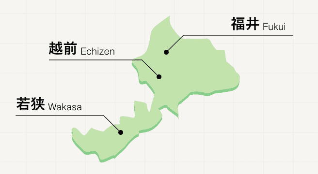
Northeast of Kyoto, the ancient Tojinbo Cliffs separate Fukui prefecture from the Sea of Japan in a stretch of land well worth exploring. Water sports and seaside delicacies are available in abundance as the spectacular rugged coastline flattens down into beaches to the west of the prefecture, while inland, Fukui is home to Zen Buddhist temples and historic ruins.
Fukui Photo Album

Best of Fukui
Search by Region
-
- Hokkaido / Tohoku
- Hokkaido
- Aomori
- Iwate
- Miyagi
- Akita
- Yamagata
- Fukushima
-
- Kanto
- Ibaraki
- Tochigi
- Gunma
- Saitama
- Chiba
- Tokyo
- Kanagawa
-
- Koshinetsu / Hokuriku
- Niigata
- Toyama
- Ishikawa
- Fukui
- Yamanashi
- Nagano
-
- Tokai
- Gifu
- Shizuoka
- Aichi
- Mie
-
- Kinki
- Shiga
- Kyoto
- Osaka
- Hyogo
- Nara
- Wakayama
-
- Chugoku
- Tottori
- Shimane
- Okayama
- Hiroshima
- Yamaguchi
-
- Shikoku
- Tokushima
- Kagawa
- Ehime
- Kochi
-
- Kyushu / Okinawa
- Fukuoka
- Saga
- Nagasaki
- Kumamoto
- Oita
- Miyazaki
- Kagoshima
- Okinawa


