Lake Spots in Toyama Area
Area
-
-
Toyama


-
-
Toyama

Category
-
- Lake Kurobe
- Travel / Tourism
- Toyama Pref. Nakanikawaguntateyamamachi Ashikuraji
- "This water reservoir for Kurobe Dam is located approximately 15 minutes from Ogizawa Station using the Kanden Tunnel Trolley Bus. A huge artificial lake that dams the Kurobe Gorge, it is known as ""Kuroyon."" Japan's largest dam with a height of 186 meters, it has a beautiful arch. A world-class lake in all respects, it is said to have a total water storage capacity of approximately 200 million tons. The lake's surface shines emerald green, and it is perfect for sightseeing in the summer because of its cool temperatures. Over 10 tons of water flows out per second when water is discharged from the dam every year at a fixed time, making it impressive and a big attraction."

-
- Lake Arimine
- Travel / Tourism
- Toyama Pref. Toyamashi Arimine
- This artificial lake in Arimine, Toyama City was created by the construction of Arimine Dam. The entire area has been designated as a prefectural natural park. The Arimine Rindo (forest road) that runs along the lake's shore offers amazing views of seasonal sights including vibrant green forests, the magnificent Tateyama Mountain Range, burning red autumn foliage, and the lake's mysterious surface. Make sure to catch a glimpse of the wondrous sight of the lake's surface hidden by the morning mist. The lake also has camping and lodging facilities, meaning that visitors can take their time to enjoy the area's natural beauty. Due to heavy snowfall, the Arimine Rindo that encircles the lake is only open from June to early November. The road is also subject to closure depending on rainfall levels, so check before visiting.

-
- Chinoike (Blood Pond)
- Travel / Tourism
- Toyama Nakaniikawa-gun Tateyamamachi Ashikuraji Division Dodaira
- "It is one of the Tateyama Hells visited by believers in the age of religious asceticism, and is also called ""Blood Pond Hell."" It contains iron oxide and appears blood red in color; although it is called a pond, it is more like a puddle of water, which is the result of water accumulating in the crater."
-
- Kadokawa Dam (Uozu)
- Travel / Tourism
- Toyama Uozu-shi
-
- Nawagaike
- Travel / Tourism
- Toyama Pref. Nantoshi Minotani
-
- Aso no Kamaike Pond
- Travel / Tourism
- Toyama Nakaniikawa-gun Kamiichimachi Aso
-
- Kataji no Ike
- Travel / Tourism
- Toyama Nakaniikawa Gujo-shi Machi Kataji
-
- Kamiichikawa Dai 1 Dam Lake
- Travel / Tourism
- Toyama Nakaniikawa Gujo-shi Machi Inamura
-
- Tuburachi
- Travel / Tourism
- Toyama Pref. Nakanikawagunkamichimachi Oiwa
-
- Tori Dam Lake
- Travel / Tourism
- Toyama Nanto-shi Tori
-
- Funato Dam Lake
- Travel / Tourism
- Toyama Tonami-shi Shogawamachi Kanaya
-
- Mizunashi Dam Lake
- Travel / Tourism
- Toyama Nanto-shi Togamura Mizunashi
-
- Lake Katsura
- Travel / Tourism
- Toyama Nanto-shi

Toyama Areas
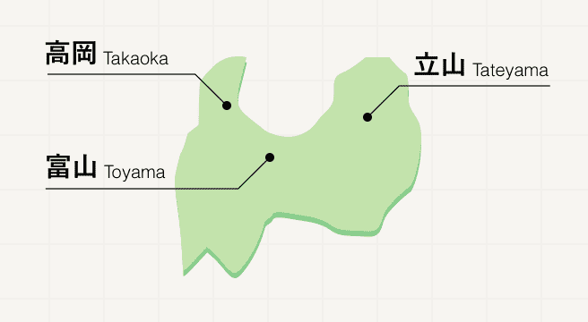
Toyama is one of the three prefectures that house the Japanese Alps, with its southern and eastern borders comprising one long stretch of mountains, out of which the Tateyama Kurobe Alpine Route is forged. While traditional crafts fill the northern coastal cities of Toyama and Takaoka, thatched roof houses offer unrivalled views against a backdrop of fantastic scenery at Gokayama in the mountainous area in the south of the prefecture.
Toyama Photo Album
Best of Toyama
Search by Region
-
- Hokkaido / Tohoku
- Hokkaido
- Aomori
- Iwate
- Miyagi
- Akita
- Yamagata
- Fukushima
-
- Kanto
- Ibaraki
- Tochigi
- Gunma
- Saitama
- Chiba
- Tokyo
- Kanagawa
-
- Koshinetsu / Hokuriku
- Niigata
- Toyama
- Ishikawa
- Fukui
- Yamanashi
- Nagano
-
- Tokai
- Gifu
- Shizuoka
- Aichi
- Mie
-
- Kinki
- Shiga
- Kyoto
- Osaka
- Hyogo
- Nara
- Wakayama
-
- Chugoku
- Tottori
- Shimane
- Okayama
- Hiroshima
- Yamaguchi
-
- Shikoku
- Tokushima
- Kagawa
- Ehime
- Kochi
-
- Kyushu / Okinawa
- Fukuoka
- Saga
- Nagasaki
- Kumamoto
- Oita
- Miyazaki
- Kagoshima
- Okinawa


