Nature Spots in Niigata Area
Area
-
-
Niigata


-
-
Niigata

Category
-
- Meoto Iwa (Wedded Rocks)
- Travel / Tourism
- Nigata Pref. Sadoshi Takose
- Sado Island is the source for many legends in the Kojiki (Japan's Records of Ancient Matters). Meoto Iwa Rocks near Nanaura Beach is one such legend. It is said that after the god Izanagi and goddess Izanami created Japan they made rocks in their image to heal their fatigue. Legend states that Meoto Iwa are those rocks created in their image and that the nearby islands came forth from those rocks. Due to this legend the rocks draw those seeking good childbirth and strong marriage as well as plenty of tourists. There are other sources of legend including Nekoiwa and Hokakeiwa as well as plenty of reefs. Making this the perfect place to watch the sunset and beautiful natural formations.

-
- Awashima Island
- Travel / Tourism
- Awashimura Village, Iwafune-gun, Niigata Prefecture
- This small island measuring approximately ten square kilometers floats in the Sea of Japan in the northern reaches of Niigata Prefecture. There are some amazing sights to be had despite from the wonderful beach front to the east of 265-meter-tall Mt. Koshibayama, to the sheer precipice dropping off its western face. There are plenty of camp-grounds and lots of ways to enjoy getting in touch with nature such as rental bicycles that you can use to get around the island. To get to Awashima Island you can take a ferry from either Niigata Port or Iwafune Port. Awashima is known for its Wappa, a circular bento lunch box, into which they put Isou rock-fish and miso before cooking it over red-hot stones in a dish called Wappani. Another popular local dish is Imodako, which is a mix of local potatoes and octopus cooked together.

-
- Shioritoge Pass
- Travel / Tourism
- Nigata Pref. Uonumashi
- This mountain pass is along National Route 352 in Uonuma City, Niigata Prefecture. At its highest point you'll find the start of the trailhead to climb Mt Echigo-Komagatake, one of Japan's 100 most famous mountains. Every October the Uonuma City Tourist Association offers a shuttle bus called Unkai and Takigumo, a prime spot for photography. Also, from mid-October to early-November take time to enjoy the various autumn colors painting the scenery as you travel along this beautiful mountain pass. The pass is open to traffic from mid-June through early-November. During the winter the pass is closed due to snow and you will be unable to use it to access Fukushima.

-
- Kakuda Cliffs
- Travel / Tourism
- Niigata Prefecture Niigata City Nishika-ku
- This cape is at the end of a ridge off of Mt. Kakudayama. Kakuda Cape Lighthouse was first lit in 1959. A huge sand-dune known as Niigata Sand-dune runs north from the cape towards Murakami City. The south side is mountainous along which runs the picturesque Echigo-Nanaura Seaside Line and on a clear day you can see across the sea to Sado Island. While normally you cannot enter the lighthouse during events such as Marine Day it is open to the public.

-
- Lake Daigenta
- Travel / Tourism
- Nigata Pref. Minamiuonumagunyuzawamachi Tsuchidaru
- This lake is 20-minutes by car from the Yuzawa Interchange. It is a man-made lake made by the damming of Daigenta River by the first arch shaped dam in Japan, one of the Tangible Cultural Properties of Japan. Surrounded by magnificent scenes of nature including Mt. Daigenta, also called the Matterhorn of the Orient, the lake is famous for its beautiful seasonal scenery from verdant greens to autumn reds. The lake surface is like a painting reflecting the scenery and during the summer you can take a boat out over the lake. The lake is 1.5 kilometers in circumference and a walk around the lake takes approximately 40 minutes. It's a peaceful walk and the laid-back hiking trail is very popular. Construction to reinforce the aging Daigenta dam will continue as planned until 2020. While under construction there will be restricted access.

-
- Mt. Sakado
- Travel / Tourism
- Nigata Pref. Minamiuonumashi Sakado
- Mt. Sakado is a 20-minute walk from Muikamachi Station. As the ancient site of Sakado Castle the mountain has become symbolic to the people of Minamiuonuma City. Standing 634 meters high there is a hiking course from the base to the summit that takes approximately one hour. Of the four fields of dogtooth violets in the city this is the most popular. The best time to see them is from early-April to early May and as you hike from the base to the summit you can enjoy the flowers dotting the landscape including anemones, asteroids, and oriental swamp pinks along with the dogtooth violets. From the summit you can see the mountains all the way along the Joetsu border to the Uonuma Basin.
-
- Kujiranami and Omigawa Beaches
- Travel / Tourism
- Nigata Pref. Kashiwazakishi Kujiranami Qinghai River
- Just a one-minute walk from JR Kujiranami Station, these beaches represent Niigata in the list of Japan's top 100 beaches. With their easy access from JR Kujiranami Station they draw numerous visitors from all over the country. The road from the station to the beach is lined with shops and during beach season is packed with people. And with the lifeguards on duty coming from the Air-sea rescue team you can bring your children for a dip in the sea without worry. The shore is a reef area scattered with rocks making the beach from Kujiranami to the mouth of the Oumi River a picturesque view, and the beach is known as a wonderful spot to view the setting sun.
-
- Sasagamine Highland
- Travel / Tourism
- Nigata Pref. Myoukoushi Suginosawa
- This highland sits at 1,300 meters above sea level at the foot of Mt. Myoko, chosen as one of Japan's 100 famous mountains. It is 40 minutes by car from the Myoko Kogen Interchange and is well known for its beautiful autumn colors. Scattered with giant Japanese elms it gives the impression of a European plain and the walking paths, fields, and camp grounds are filled with seasonal flowers. From spring to fall crowds of people come to enjoy mountain climbing and trekking. The Sasagamine Loop Trail is a recommended walking course that takes about one hour to complete and will let you enjoy the verdant greens of spring or changing fall leaves. It loops around the ranch, Udana spring, Shimizugaike pond, and a German spruce forest.

-
- Kamogahana Observation Deck (Koibito Misaki)
- Travel / Tourism
- Niigata Kashiwazaki-shi Omigawa 133-1

-
- Yoneyama Fukuura Hakkei
- Travel / Tourism
- Niigata Kashiwazaki-shi Yoneyamacho Hoka

-
- Iwakubi Shoryutanada
-
![rating-image]() 4.05 Reviews
4.05 Reviews - Travel / Tourism
- Nigata Pref. Sadoshi Iwakubi
-
![]()
佐渡の中でも細い道を登ること20分にある岩首昇竜棚田展望が棚田を眺めるのにおすすめ! 棚田と一緒に眺めることできる佐渡海峡と天気の良い日には新潟市街地も見れるそうです。ぼんやりと眺めながら過ごす贅沢な時間でした。
-
- Benkei no Hasami Iwa
-
![rating-image]() 4.52 Reviews
4.52 Reviews - Travel / Tourism
- Niigata Sado-shi Shimoaikawa
-
![]()
道路沿いにありますが、とても分かり辛いです。近くには無料の駐車場があります。駐車場から徒歩1分くらいです。
-
- Mt.Nokogiri
- Travel / Tourism
- Niigata
-
- Aburumagawa Valley
- Travel / Tourism
- Niigata Uonuma-shi Oshirakawa Hoka
-
- Ikazawa Valley
- Travel / Tourism
- Niigata Minamiuonuma Shimizuse
-
- Gejo Kawa Dam Management Office
- Travel / Tourism
- Niigata Kamo-shi Gejo 879
-
- Uchi no Kura Dam Management Office
- Travel / Tourism
- Niigata Shibata-shi Odo 3155
-
- Sagurigawa Dam
- Travel / Tourism
- Niigata Minamiuonuma-shi
-
- Ikarashi Riv.
- Travel / Tourism
- Niigata Sanjo-shi
-
- Mt.Yamamoto (Prefectural Nature Park)
- Travel / Tourism
- Niigata Ojiya-shi Yama Motoyama


Niigata Areas
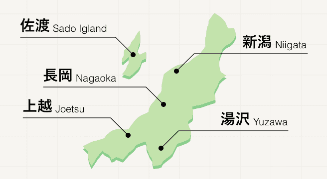
Found along the northwestern coast of Japan, Niigata prefecture is celebrated for its high-quality rice and breathtaking nature, most notably its spectacular mountains, whose white peaks draw in snow sports lovers from far and wide over the winter months. Hit the slopes at Yuzawa, pick out your favourite modern artist at Echigo Tsumari, or take a ferry over to Sado Island for an extra adventure.
Niigata Photo Album
Best of Niigata
Search by Region
-
- Hokkaido / Tohoku
- Hokkaido
- Aomori
- Iwate
- Miyagi
- Akita
- Yamagata
- Fukushima
-
- Kanto
- Ibaraki
- Tochigi
- Gunma
- Saitama
- Chiba
- Tokyo
- Kanagawa
-
- Koshinetsu / Hokuriku
- Niigata
- Toyama
- Ishikawa
- Fukui
- Yamanashi
- Nagano
-
- Tokai
- Gifu
- Shizuoka
- Aichi
- Mie
-
- Kinki
- Shiga
- Kyoto
- Osaka
- Hyogo
- Nara
- Wakayama
-
- Chugoku
- Tottori
- Shimane
- Okayama
- Hiroshima
- Yamaguchi
-
- Shikoku
- Tokushima
- Kagawa
- Ehime
- Kochi
-
- Kyushu / Okinawa
- Fukuoka
- Saga
- Nagasaki
- Kumamoto
- Oita
- Miyazaki
- Kagoshima
- Okinawa


