Nature Spots in Bandai Highland / Inawashiro Area
Area
-
-
Fukushima


-
-
Fukushima

Category
-
- Goshikinuma Lakes
- Travel / Tourism
- Fukushima Pref. Yamagunkitashiobaramura Hibara
- The Goshikinuma (five-colors) lake group consists of dozens of large and small lakes, such as the Bishamon-numa, the Akanuma, and the Rurinuma. The water color of each lake varies according to the size of the particles in the water. The emerald green or cobalt blue shining water surface is mysteriously beautiful. It takes an hour and a half to stroll along the walking path.

-
- Lake Hibara
- Travel / Tourism
- Fukushima Pref. Yamagunkitashiobaramura Hibara
- Lake Hibara is the largest lake in the Urabandai area. It has a circumference of 32 kilometers and a maximum depth of 31 meters. The beautiful blue waters offer a gentle surface, and there are sightseeing cruises, campgrounds and walking trails to better enjoy the area. In winter, you can go ice fishing for Japanese pond smelt, so there’s something all year round.

-
- Tatsusawa Fudo Falls
- Travel / Tourism
- Fukushima Pref. Yamaguninawashiromachi
- This waterfall is only a 10-minute walk from Nakanosawa Hot Spring. It got its name after the Fudo River where a Fudoson (god of fire) is enshrined at the mouth of the river. There is a spectacular ‘male’ waterfall that flows down a giant boulder, and an elegant quietly flowing ‘female’ waterfall on the west side, creating a beautiful contrast. Fall is one of the best times to go.

-
- Mt. Bandai
- Travel / Tourism
- Fukushima Pref. Yamaguninawashiromachi
- This is an active volcano located in Inawashiro Town, Yama Country, Fukushima Prefecture, and is designated as one of the 100 most famous mountains in Japan. It has an altitude of about 1,816 meters. The view from the top of the mountain is wonderful, and you can see the scenery of the mountain foothills, to the huge peaks of the Nasu Mountain Range to Mt. Aizu Komagatake. In the foothills to the south of Lake Inawashiroko, is what is called Omote (the front side) Bandai and to the north is called Ura (behind) Bandai, each with various trekking courses. The Goshikinuma Nature Trek that goes around the mysteriously colored lakes of Ura Bandai, and the Happodai Mountain Climbing Path where the path is not steep and the climb is easy, are popular.

-
- Urabandai Highland
- Travel / Tourism
- Kitashiobara Village, Yama-gun, Fukushima Prefecture
- "Urabandai Highland is a highland area to the north of Mt. Bandai, located around 25 minutes' drive from Inawashiro Bandai Kogen Interchange on the Ban-Etsu Expressway. Viewed from the south, Mt. Bandai has a very neat, mountain-like appearance, but the north side has a rough, irregular shape due to sectoral collapse, hence the name ""Urabandai"" (meaning ""Back of Mt. Bandai""). Urabandai is famous for the Goshikinuma lakes and ponds; there are many lakes and ponds, with water that takes a wide range of different colors, including emerald green and cobalt blue. Urabandai is a great place to visit in spring (for the new greenery) and autumn (for the autumn foliage), but it is also well worth seeing in winter, when visitors can enjoy snowshoe-trekking. Special guided tours, available only in winter, take visitors to see Goshikinuma ponds when they are at their most magical and mysterious."

-
- Oguninuma Marshland
- Travel / Tourism
- Fukushima Yama-gun Kitashiobaramura
- A lake in Kitashiobara Village, Yama County. It's a caldera like that was formed by volcanic activity nearly 500,000 years ago. The lake sits at an altitude of 1000 meters and the Oguninuma marshland that surrounds the lake has been designated the Oguninuma Marshland Botanical Area, a Japanese Natural Monument. The area is filled with an abundance of nature and in late June a large number of Nikko day lilies come into bloom.

-
- Nakatsugawa Gorge
- Travel / Tourism
- Kitashiobara Village, Yama-gun, Fukushima Prefecture
- A gorge located in the Urabandai area in Kitashiobara Village, Yama County, Fukushima Prefecture. Fishing for char and Japanese salmon is popular here, as stroll the trekking course which follows the gorge. The gorge is also a renowned destination for fall foliage viewing and visitors can take in the scenery from bridges which span the gorge. The gorge has also been selected as one of the eight most picturesque sights in Inawashiro and many visitors come here to enjoy its beauty.

-
- Lake Akimoto
- Travel / Tourism
- Foshima prefecture Yama-gun, Kitashiobara village/Inawashiro-machi
- A lake located in Bandai-Asahi National Park, a park which spans Kitashiobara Village and Inawashiro Town in Yama County, Fukushima Prefecture. The lake is also known as one of the Three Lakes of Urabandai. Bass fishing is popular here, and the lake has also become a renowned destination for Japanese pond smelt fishing in winter. Finally, the lake is a popular location to take photos, and during the fall foliage season, many amateur photography lovers come here to take pictures of the area just as the sun is rising in the morning.

-
- Bishamon Marsh
- Travel / Tourism
- Fukushima Pref. Yamagunkitashiobaramura Hibara
- A wetlands area in Bandai-Asahi National Park in Kitashiobara Village, Yama County , Fukushima Prefecture. This is the largest marsh of the Goshiki-numa, the Five Colored Marshes. Visitors to the area can enjoy the picturesque, seasonal scenery created by the emerald green waters and Mt. Bandai. The popular Goshiki-numa Nature Trail hiking course is popular and travelled by large numbers of visitors during the fall foliage season.

-
- Oguninuma Wetlands
- Travel / Tourism
- Fukushima Pref. Yamagunkitashiobaramura Hibara
- A wetlands area located on a highland over 1,000 meters above sea level in Kitashiobara Village, Yama County, Fukushima Prefecture. The area is famous for its community of Nikko day lilies, which come into bloom each year from late June to early July. This lily species has been designated a National Natural Monument and many people come here to view the blossoms. During the blooming season, traffic by private vehicles is restricted for environmental conservation reasons, and visitors must take a shuttle bus which runs during this time.

-
- Mt. Issaikyo
- Travel / Tourism
- Fukushima Yama-gun Inawashiromachi Hoka

-
- Ryofu Pass
- Travel / Tourism
- Fukushima Yama-gun Kitashiobaramura
- A pass on the Bandai-Azuma Lake Line, which runs through wooded lands, giving visitors a view of the three lakes (Lake Hibara, Lake Onogawa, and Lake Akimoto) that were formed by the eruption of Mt. Bandai. From the 870-meter above sea level pass, Lake Hibara and Lake Onogawa can be seen straight ahead. The area's autumn leaves are especially beautiful. The road is closed between mid-November and late April.

-
- Mt.Okura Kotaki
- Travel / Tourism
- Fukushima Yama-gun Inawashiromachi
-
- Maboroshinotaki
- Travel / Tourism
- Yama-gun, Fukushima Prefecture Bandai-machi
-
- Bandai San Happodai Mountain trailhead
- Travel / Tourism
- Fukushima Yama-gun Bandai Machi Bandai
-
- Bandai San Kawakami Mountain trailhead
- Travel / Tourism
- Fukushima Yama-gun Inawashiromachi Yamanokami Hara
-
- Bandai San Inawashiro Mountain trailhead
- Travel / Tourism
- Fukushima Yama-gun Inawashiromachi Hayama
-
- Bandai San Ura Bandai Mountain trailhead
- Travel / Tourism
- Fukushima Yama-gun Kitashiobaramura Hibara Yu Hirayama
-
- Bandai San Shibutani Mountain trailhead
- Travel / Tourism
- Fukushima Yama-gun Inawashiromachi Shibutani
-
- Bandai San Okinashima Mountain trailhead
- Travel / Tourism
- Fukushima Yama-gun Inawashiromachi Tenkyodai

Fukushima Areas
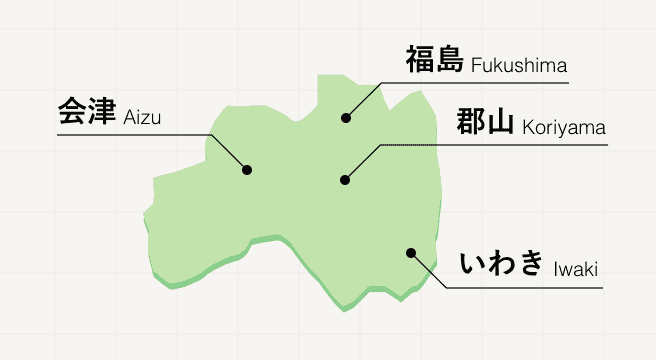
Fukushima is a blend of fantastic scenery, delectable sake, and kaleidoscopic colors. This nature-rich prefecture displays its splendor from the hidden Abukuma Cave underground right to the top of its sky-high mountain road, known as the Bandai-Azuma Skyline.
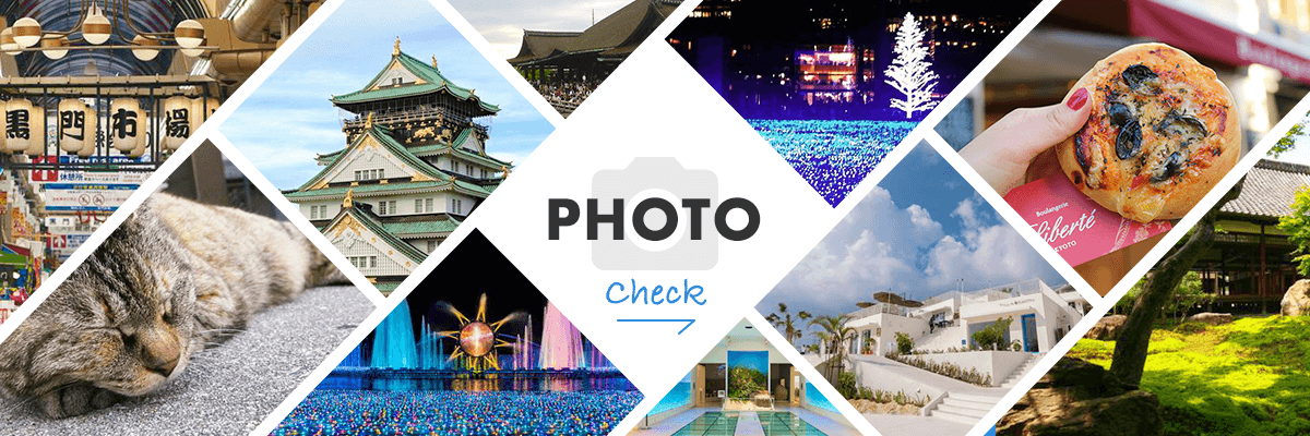
Fukushima Photo Album
Best of Fukushima
Search by Region
-
- Hokkaido / Tohoku
- Hokkaido
- Aomori
- Iwate
- Miyagi
- Akita
- Yamagata
- Fukushima
-
- Kanto
- Ibaraki
- Tochigi
- Gunma
- Saitama
- Chiba
- Tokyo
- Kanagawa
-
- Koshinetsu / Hokuriku
- Niigata
- Toyama
- Ishikawa
- Fukui
- Yamanashi
- Nagano
-
- Tokai
- Gifu
- Shizuoka
- Aichi
- Mie
-
- Kinki
- Shiga
- Kyoto
- Osaka
- Hyogo
- Nara
- Wakayama
-
- Chugoku
- Tottori
- Shimane
- Okayama
- Hiroshima
- Yamaguchi
-
- Shikoku
- Tokushima
- Kagawa
- Ehime
- Kochi
-
- Kyushu / Okinawa
- Fukuoka
- Saga
- Nagasaki
- Kumamoto
- Oita
- Miyazaki
- Kagoshima
- Okinawa


