Other Sightseeing Spots in Hokkaido Area
Area
-
-
Hokkaido


-
-
Hokkaido
-
-
ALL
-
- All areas
- Central Sapporo
- Sapporo Suburbs
- Otaru
- Shakotan / Yoichi
- Niseko / Lake Toya
- Hakodate
- Onuma / Matsumae / Esashi
- Asahikawa
- Furano
- Biei
- Tomakomai / Shiraoi / Noboribetsu
- Yubari / Bibai
- Hidaka
- Obihiro / Erimo
- Northern Tokachi
- Southern Tokachi
- Kushiro / Three Great Lakes
- Abashiri / Mombetsu
- Shiretoko
- Nemuro
- Wakkanai
- Rishiri / Rebun
- Eniwa / Chitose / Shikotsuko
-
ALL

Category
-
- Maruyama Observation Deck
- Travel / Tourism
- Hokkaido Nakagawa-gun Makubetsucho
- Mt. Maruyama is located to the north of Churui City, 300 meters above sea level. From the observation deck at the summit of the mountain, visitors can see the cityscape of Churui, the mountainous scenery of Hidaka, and all the way to the Pacific Ocean.

-
- Nijukken-zaka Slope
- Travel / Tourism
- Hokkaido Hakodate-shi Motomachi
- The slope is located between Daisanzaka and Nanbu-zaka, and its name comes from the 20-meter width of the road. In winter, the trees along the street are lit up to create a fantastic sight.

-
- Daisan-zaka Slope
- Travel / Tourism
- Hokkaido Hakodate-shi Motomachi Suehirocho
- The slope is located between Hachimanzaka and Nijumazaka, and is characterized by its magnificent stone pavement, selected as one of the 100 best roads in Japan by the Ministry of Land, Infrastructure, Transport and Tourism. The area is home to Motomachi Catholic Church, and is a charming blend of old Japanese townscape and exoticism.

-
- Saiwai-zaka Slope
- Travel / Tourism
- Hokkaido Hakodate-shi Funamicho
- The hill is located between Chitose-zaka and Sugatamizaka, and its name comes from the fact that Saiwaicho was created by reclaiming the bay below the hill. 620 meters long, it is one of the longest and steepest slopes in Hakodate, and the view from the top is spectacular. The former Russian Consulate is located on the way to the hill.

-
- Tomoe Ohashi Bridge
- Travel / Tourism
- Hokkaido Hakodate-shi Otemachi-Bandaicho
- This major road of 1924 meters crosses the Bay Area and also overlooks the Port of Hakodate. During the Port of Hakodate firework display the road is closed to traffic and open to pedestrians, making it a perfect viewing spot.

-
- Niijima Bridge
- Travel / Tourism
- Hokkaido Hakodate-shi Omachi

-
- Yayoi-zaka Slope
- Travel / Tourism
- Hokkaido Hakodate-shi Omachi
- The slope is located between Tokiwa-zaka and Higashi-zaka, and is the longest of the typical slopes at the foot of Mount Hakodate at about 720 m. It was originally two slopes, but was converted to one after the Great Fire and given its present name to pray for regional growth and prosperity. The area is also home to such landmarks as the Rinkai Kenkyujo (Rinkai Research Institute) and the monument to the naval deaths during the Battle of Mikimi-yaku (Battle of Mikami).

-
- Gokokujinja-zaka Slope
- Travel / Tourism
- Hokkaido Hakodate-shi Houraicho
- The street is characterized by a wide road with a green belt and a bronze statue of Kahei Takadaya, a wealthy merchant who negotiated between the Edo Shogunate and Russia. The area is lined with many famous stores that evoke a sense of history, such as Senjuan Sohonke, founded in 1860, and the teahouse Hishii, which uses a storehouse from the Meiji era (1868-1912).

-
- Hiyori-zaka Slope
- Travel / Tourism
- Hokkaido Hakodate-shi Suehirocho
- It is located between Motozaka and Hachimanzaka, and was named after the old pier at the end of the hill, from which one could see the entire port of Hakodate and the sky. The roadside is planted with hydrangeas, which are beautiful when in season.

-
- Ogon (Golden) Road (National Route 336)
- Travel / Tourism
- Hokkaido Horoizumi-gun Erimo Cho Shoya - Hirocho
- The 33.5 kilometers of the coastal, cliff top National Route 336 between Shoya District of Erimo Town and Hiroo Town is beautiful. It was named the 'Golden Road' because of the expense in construction, 'as expensive as laying the road with gold'.

-
- Chachanobori Slope
- Travel / Tourism
- Hokkaido Hakodateshi Motomachi
- Chachanobori Slope is a narrow slope of road passing between Hakodate St. John’s Church and Hakodate Orthodox Church up the road from Motomachi Catholic Church on the Daisanzaka Slope. In the Ainu language ‘cha cha’ means grandfather or old man. As the name suggests, it’s a steep slope, so you really need to bend over at the waist like an old man in order to climb up. From the top of the slope however you can get beautiful city views of Hakodate. You can enjoy the exotic beauty of this slope especially in fall when the Japanese rowan trees splash the street with their distinctive red color.

-
- Motoizaka Slope
- Travel / Tourism
- Hokkaido Hakodateshi Suehirochou
- Motoizaka takes its name from the fact that in the Meiji period it was used as a milestone to measure distances. Here you can find the former British Consulate, the Commemorative Statue of Commodore Perry, and the impressive Old Public Hall of Hakodate Ward with its pale blue and yellow appearance, and from Motomachi Park at the top of the slope you can see the city of Hakodate, one of Hakodate’s most famous sights.

-
- Tsubetsu Pass Observatory Facility
- Travel / Tourism
- Hokkaido Abashiriguntsubetsuchou Kamisato
- This observation deck is positioned at an altitude of 947 meters on the pass between Tsubetsu Town and Teshikaga Town. From here you can see Lake Kussharo down below and the Shiretoko Mountains in the distance. If the weather conditions are right, sometime between the months of June and October you can witness a sea of cloud completely cover Lake Kussharo. Watching the sun rise from out of this sea of white cloud is an unbelievable sight.

-
- Shirakaba Highway
- Travel / Tourism
- Hokkaido Kamikawagumbieichou Shirogane
- About 16 kilometers from JR Biei Station is the Shirakaba Highway, a stretch of road approximately four kilometers in length heading towards Shirogane Hot Spring. Shirakaba, which has grown naturally wild from the mud slides of the volcanic eruption of Mt. Tokachi in 1926, has been selected as one of Hokkaido’s top 100 natural sights. You can enjoy bird watching and long forest walks along the pathway which follows the Shirakaba Highway.

-
- Cape Peshi Observatory
- Travel / Tourism
- Hokkaido Rishirigunrishirifujichou Oshidomari Minatomachi
- This observatory is located near the tip of Cape Peshi on Rishiri Island, Hokkaido. When the weather is good, the observatory provides excellent views of Mt. Rishiri, Rebunto Island and the mainland of Hokkaido. The view in the early morning, as the sun rises over the Sea of Japan, giving both the sea and sky an orange tint, is particularly spectacular.

-
- Yuhigaoka Observatory
- Travel / Tourism
- Hokkaido Rishirigunrishirifujichou Oshidomari Fujino
- As its name (“Hill of the Setting Sun”) suggests, the Yuhigaoka Observatory is a marvelous place for watching the sun go down. With a superb 360-degree panoramic view of Mt. Rishiri (the iconic symbol of Rishiri Island), the Japan Sea, Rebunto Island, etc., the experience of watching all of this gorgeous scenery bathed in an orange light by the setting sun is truly awe-inspiring.

-
- Sanai-no-Oka Observatory Park
- Travel / Tourism
- Hokkaido Kamikawagumbieichou Sanai Green
- Located just off the famous “Panorama Road,” the Sanai-no-Oka Observatory Park has an observation platform with a distinctive red pyramid-shaped roof, where visitors relax and enjoy views over gently rolling hills. There are also toilets available, making this a convenient place to stop for a break.

-
- Takkobu Boardwalk
- Travel / Tourism
- Hokkaido Kushirogunkushirochou Tatsukobu
- The Takkobu Boardwalk is a 2.3-kilometer-long walkway in the hills on the northern side of Lake Takkobu in the Kushiro Shitsugen. Visitors can observe a wide variety of plants and animals, including distinctive raised tussocks and wild birds.

-
- Highland Koshimizu 725
- Travel / Tourism
- Hokkaido Shari-gun Koshimizu-machi MOTOYAMA 1
- The Highland Koshimizu 725 rest-house is located in the northern corner of Akan National Park, on the slopes of Mt. Mokoto (which is 1,000 meters high). The observation terrace provides a superb 300-degree panoramic view of the Sea of Okhotsk, the Shiretoko Mountain Range, Lake Kussyaro, etc. In the early morning on days when the weather is good, visitors can sometimes see the spectacular “Sea of Clouds” phenomenon. The rest-house has a highly-regarded restaurant where visitors can enjoy dishes made using local ingredients.

-
- Wall Street of the North
- Travel / Tourism
- Hokkaido Otarushi Ironai
- From the latter part of the Meiji period through into the early years of the Showa era, Otaru was Hokkaido’s main economic and financial center. The streets were lined with trading company offices and banks, and the city center had an air of prosperity about it that led to it being nicknamed the “Wall Street of the North.” Today, many of these fine old offices have been repurposed; for example, the former Otaru Branch of the Bank of Japan now houses the Bank of Japan Otaru Museum (a banking museum), and other buildings such as the former headquarters of Hokkaido Bank have also been put to new uses, housing museums, restaurants, etc., but there are still many traces of the past remaining.

Central Sapporo
Sapporo Suburbs
Otaru
Shakotan / Yoichi
Niseko / Lake Toya
Hakodate
Onuma / Matsumae / Esashi
Asahikawa
Furano
Biei
Tomakomai / Shiraoi / Noboribetsu
Yubari / Bibai
Hidaka
Obihiro / Erimo
Northern Tokachi
Southern Tokachi
Kushiro / Three Great Lakes
Abashiri / Mombetsu
Shiretoko
Nemuro
Wakkanai
Rishiri / Rebun
Eniwa / Chitose / Shikotsuko

Hokkaido Areas
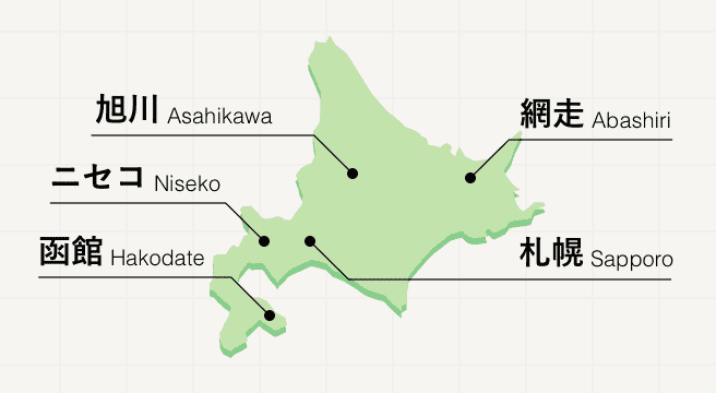
Not just a prefecture but an island of its own, Hokkaido is the most northerly prefecture and island of the Japanese archipelago. Arriving in Hokkaido, which is rural and bursting with breathtaking nature, means entering a world where vast national parks, towering mountains, and natural hot springs can be found at every turn. Come December, these natural splendors freeze over and morph into a winter wonderland.
Hokkaido Photo Album
Best of Hokkaido
Search by Region
-
- Hokkaido / Tohoku
- Hokkaido
- Aomori
- Iwate
- Miyagi
- Akita
- Yamagata
- Fukushima
-
- Kanto
- Ibaraki
- Tochigi
- Gunma
- Saitama
- Chiba
- Tokyo
- Kanagawa
-
- Koshinetsu / Hokuriku
- Niigata
- Toyama
- Ishikawa
- Fukui
- Yamanashi
- Nagano
-
- Tokai
- Gifu
- Shizuoka
- Aichi
- Mie
-
- Kinki
- Shiga
- Kyoto
- Osaka
- Hyogo
- Nara
- Wakayama
-
- Chugoku
- Tottori
- Shimane
- Okayama
- Hiroshima
- Yamaguchi
-
- Shikoku
- Tokushima
- Kagawa
- Ehime
- Kochi
-
- Kyushu / Okinawa
- Fukuoka
- Saga
- Nagasaki
- Kumamoto
- Oita
- Miyazaki
- Kagoshima
- Okinawa


